Pharmacy nearby Sonol Sp. z o.o.
Poland
Pharmacy nearby Sonol Sp. z o.o.
Sonol Sp. z o.o.
26, Hetmańska, 60-101, Poznań, Poznań, PL Polska
contacts phone
:
+48 61 862 70 95
Latitude:
52.3913439
, Longitude:
16.8900559
larger map & directions
read more
nearest Pharmacy
296 m
Apteka Całodobowa Dr.Max
Głogowska 120, Poznań
Pharmacy
read more
296 m
Apteka Dr.Max
Głogowska 120, Poznań
Pharmacy
read more
369 m
Apteka Familia
Głogowska 132/140, Poznań
Pharmacy
read more
370 m
Apteka Dyżurna
Głogowska 111, Poznań
Pharmacy
read more
397 m
DOZ Apteka dbam o zdrowie Apteka Św. Łazarza
Głogowska 107/109, Poznań
Pharmacy
read more
412 m
Apteka Verus
60-237, Kasprzaka 16, Poznań
Pharmacy
read more
458 m
Melissa-Bis
Morawskiego 1, Poznań
Pharmacy
read more
459 m
Apteka MEDKOM
Morawskiego 2b, Poznań
Pharmacy
read more
459 m
Apteka MEDKON
Morawskiego 2b, Poznań
Pharmacy
read more
484 m
Apteka Panaceum
Palacza 36, Poznań
Pharmacy
read more
501 m
Pod Niedźwiedziem
Głogowska 146, Poznań
Pharmacy
read more
612 m
Apteka Prima
Kosynierska 6, Poznań
Pharmacy
read more
720 m
Apteka Pod Jemiołą
Sielska 32, Poznań
Pharmacy
read more
734 m
Ziko Apteka
Głogowska 83, Poznań
Pharmacy
read more
750 m
Apteka Dla Ciebie
rynek Łazarski 1, Poznań
Pharmacy
read more
804 m
Euro-Apteka Sp. z o.o.
Głogowska 72, Poznań
Pharmacy
read more
836 m
Apteka Zdrowa Wielkopolska
Kącik 5 (SPOŁEM), Poznań
Pharmacy
read more
840 m
Apteka Dr.Max
Łukaszewicza 34/36, Poznań
Pharmacy
read more
900 m
Apteka Promienna
Palacza 96, Poznań
Pharmacy
read more
905 m
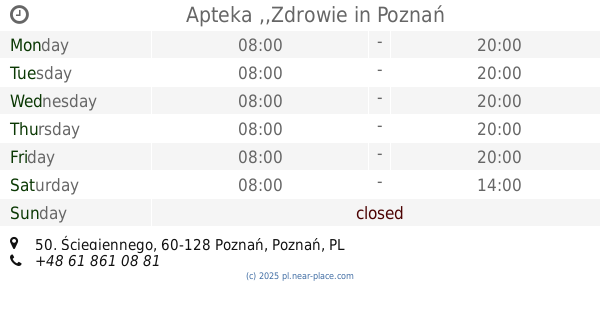
Apteka ,,Zdrowie
Ściegiennego 50, Poznań
Pharmacy
read more
910 m
Apteka ROSA
rynek Łazarski 7, Poznań
Pharmacy
read more
946 m
Apteka Galenica
Głogowska 146, Poznań
Pharmacy
read more
1.034 km
Apteka Słoneczna
Orężna 13, Poznań
Pharmacy
read more
1.121 km
Apteka Centrum
Głogowska 53, Poznań
Pharmacy
read more
1.193 km
Pod Dębem
Matejki 56, Poznań
Pharmacy
read more
📑
all categories
Accounting
Administrative area level 1
Administrative area level 2
Airport
Amusement park
Aquarium
Art gallery
Atm
Bakery
Bank
Bar
Beauty salon
Bicycle store
Book store
Bowling alley
Bus station
Cafe
Campground
Car dealer
Car rental
Car repair
Car wash
Casino
Cemetery
Church
City hall
Clothing store
Colloquial area
Convenience store
Courthouse
Dentist
Department store
Doctor
Electrician
Electronics store
Embassy
Finance
Fire station
Florist
Food
Funeral home
Furniture store
Gas station
General contractor
Grocery or supermarket
Gym
Hair care
Hardware store
Health
Hindu Temple
Home goods store
Hospital
Insurance agency
Intersection
Jewelry store
Laundry
Lawyer
Library
Light rail station
Liquor store
Local government office
Locality
Locksmith
Lodging
Meal delivery
Meal takeaway
Mosque
Movie rental
Movie theater
Moving company
Museum
Natural feature
Neighborhood
Night club
Painter
Park
Parking
Pet store
Pharmacy
Physiotherapist
Place of worship
Plumber
Point of interest
Police
Political
Post office
Premise
Real estate agency
Restaurant
Roofing contractor
Route
Rv park, camping
School
Shoe store
Shopping mall
Spa
Stadium
Storage
Store
Subpremise
Subway station
Supermarket
Synagogue
Taxi stand
Train station
Transit station
Travel agency
University
Veterinary care
Zoo
administrative area level 3
sublocality level 1
↑