Pharmacy nearby Apteka ,,Zdrowie
Poland
Pharmacy nearby Apteka ,,Zdrowie
Apteka ,,Zdrowie
50, Ściegiennego, 60-128, Poznań, Poznań, PL Polska
contacts phone
:
+48 61 861 08 81
Latitude:
52.388611
, Longitude:
16.8774958
larger map & directions
read more
nearest Pharmacy
243 m
Raszyńska. Apteka
Ściegiennego 65, Poznań
Pharmacy
read more
364 m
Apteka Promienna
Palacza 96, Poznań
Pharmacy
read more
490 m
Apteka Panaceum
Palacza 36, Poznań
Pharmacy
read more
547 m
Apteka Pod Jemiołą
Sielska 32, Poznań
Pharmacy
read more
728 m
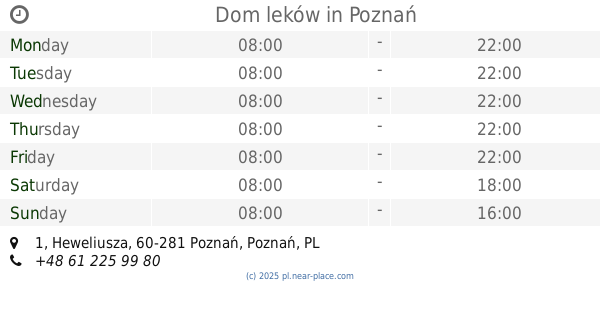
Dom leków
Heweliusza 1, Poznań
Pharmacy
read more
813 m
Apteka Prima
Kosynierska 6, Poznań
Pharmacy
read more
874 m
Apteka Familia
Głogowska 132/140, Poznań
Pharmacy
read more
885 m
Pod Niedźwiedziem
Głogowska 146, Poznań
Pharmacy
read more
904 m
Apteka Kaja mgr Katarzyna Jarzembowska
Palacza 141/143, Poznań
Pharmacy
read more
905 m
Sonol Sp. z o.o.
Hetmańska 26, Poznań
Pharmacy
read more
907 m
Pod Słońcem. Apteka
Keplera 1, Poznań
Pharmacy
read more
907 m
Under the sun. pharmacy
Keplera 1, Poznań
Pharmacy
read more
920 m
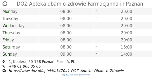
DOZ Apteka dbam o zdrowie Farmacjanna
Keplera 1/2b, Poznań
Pharmacy
read more
928 m
Żeń-Szeń. Apteka
Newtona 14, Poznań
Pharmacy
read more
945 m
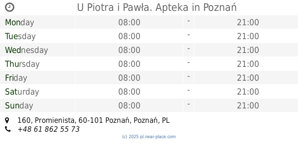
U Piotra i Pawła. Apteka
Promienista 160, Poznań
Pharmacy
read more
1.075 km
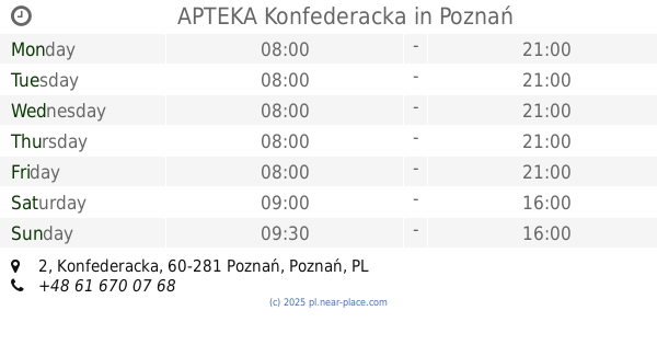
APTEKA Konfederacka
Konfederacka 2, Poznań
Pharmacy
read more
1.125 km
DOZ pharmacy care about health
Mrągowska 4, Poznań
Pharmacy
read more
1.125 km
DOZ Apteka dbam o zdrowie
Mrągowska 4, Poznań
Pharmacy
read more
1.169 km
Twoja Apteka Rodzinna
Mrągowska 4, Poznań
Pharmacy
read more
1.189 km
Sagittarius. Apteka
Cześnikowska 2, Poznań
Pharmacy
read more
1.22 km
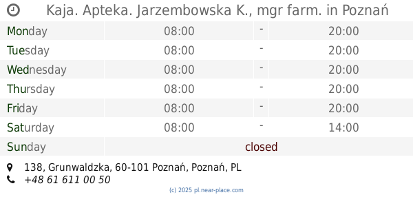
Kaja. Apteka. Jarzembowska K., mgr farm.
Grunwaldzka 138, Poznań
Pharmacy
read more
1.329 km
Apteka MEDKOM
Morawskiego 2b, Poznań
Pharmacy
read more
1.723 km
Apteka Dr.Max
Łukaszewicza 34/36, Poznań
Pharmacy
read more
1.772 km
Apteka Fundacji Uniwersytetu Medycznego
Przybyszewskiego 49, Poznań
Pharmacy
read more
1.847 km
NASZA APTEKA
Przybyszewskiego 49, Poznań
Pharmacy
read more
📑
all categories
Accounting
Administrative area level 1
Administrative area level 2
Airport
Amusement park
Aquarium
Art gallery
Atm
Bakery
Bank
Bar
Beauty salon
Bicycle store
Book store
Bowling alley
Bus station
Cafe
Campground
Car dealer
Car rental
Car repair
Car wash
Casino
Cemetery
Church
City hall
Clothing store
Colloquial area
Convenience store
Courthouse
Dentist
Department store
Doctor
Electrician
Electronics store
Embassy
Finance
Fire station
Florist
Food
Funeral home
Furniture store
Gas station
General contractor
Grocery or supermarket
Gym
Hair care
Hardware store
Health
Hindu Temple
Home goods store
Hospital
Insurance agency
Intersection
Jewelry store
Laundry
Lawyer
Library
Light rail station
Liquor store
Local government office
Locality
Locksmith
Lodging
Meal delivery
Meal takeaway
Mosque
Movie rental
Movie theater
Moving company
Museum
Natural feature
Neighborhood
Night club
Painter
Park
Parking
Pet store
Pharmacy
Physiotherapist
Place of worship
Plumber
Point of interest
Police
Political
Post office
Premise
Real estate agency
Restaurant
Roofing contractor
Route
Rv park, camping
School
Shoe store
Shopping mall
Spa
Stadium
Storage
Store
Subpremise
Subway station
Supermarket
Synagogue
Taxi stand
Train station
Transit station
Travel agency
University
Veterinary care
Zoo
administrative area level 3
sublocality level 1
↑