Pharmacy nearby DOZ pharmacy care about health
Poland
Pharmacy nearby DOZ pharmacy care about health
DOZ pharmacy care about health
Świętego Szczepana 7, Poznań Polen
contacts phone
:
+48
Latitude:
52.3717373
, Longitude:
16.9079654
read more
nearest Pharmacy
DOZ Apteka dbam o zdrowie
Świętego Szczepana 7, Poznań
Pharmacy
read more
317 m
Apteka Centrum Leków
46, Czechosłowacka, Poznań
Pharmacy
read more
317 m
Apteka Centrum Leków
Czechosłowacka 46, Poznań
Pharmacy
read more
437 m
Apteka Drosera
28 Czerwca 1956 r. 330, Poznań
Pharmacy
read more
489 m
Apteka O'Polska
Opolska 24, Poznań
Pharmacy
read more
532 m
DOZ pharmacy care about health
Jaworowa 66, Poznań
Pharmacy
read more
532 m
DOZ Apteka dbam o zdrowie
Jaworowa 66, Poznań
Pharmacy
read more
539 m
Apteka Wielkopolska - Osinowa
Osinowa 14, Poznań
Pharmacy
read more
543 m
Ardea Polska Sp. z o.o.
Jaworowa 66, Poznań
Pharmacy
read more
543 m
Apteka Jaworowa
Jaworowa 66, Poznań
Pharmacy
read more
589 m
Apteka Wielkopolska - Dębiecka
28 Czerwca 1956 r. 349, Poznań
Pharmacy
read more
652 m
Apteka Kocanka
28 Czerwca 1956 r. 261, Poznań
Pharmacy
read more
659 m
Pinia
Opolska 17, Poznań
Pharmacy
read more
721 m
Apteka Verus
Limbowa 3, Poznań
Pharmacy
read more
725 m
Apteka Bukowa
Bukowa 2A 61-445, Poznań
Pharmacy
read more
795 m
Apteka Verus
61-443, Łozowa 92, Poznań
Pharmacy
read more
795 m
Na Tarasie. Apteka
Łozowa 92, Poznań
Pharmacy
read more
928 m
Apteka Verus
Jesionowa 25, Poznań
Pharmacy
read more
1.072 km
Apteka Apis
osiedle Dębina 14, Poznań
Pharmacy
read more
1.946 km
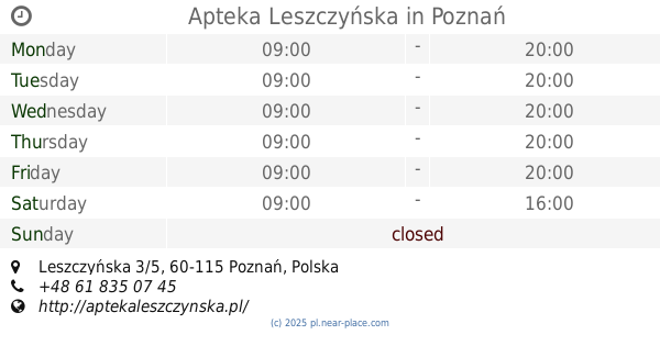
Apteka Leszczyńska
Leszczyńska 3/5, Poznań
Pharmacy
read more
1.986 km
Apteka św. Jadwigi
Kosińskiego 28, Poznań
Pharmacy
read more
2.051 km
Apteka Prima
Kosynierska 6, Poznań
Pharmacy
read more
2.057 km
Apteka Dom Leków
28 Czerwca 1956 r. 134, Poznań
Pharmacy
read more
2.117 km
Apteka WILDECKA
28 Czerwca 1956 r. 138/140, Poznań
Pharmacy
read more
2.253 km
Apteka Pod Jemiołą
Sielska 32, Poznań
Pharmacy
read more
📑
all categories
Accounting
Administrative area level 1
Administrative area level 2
Airport
Amusement park
Aquarium
Art gallery
Atm
Bakery
Bank
Bar
Beauty salon
Bicycle store
Book store
Bowling alley
Bus station
Cafe
Campground
Car dealer
Car rental
Car repair
Car wash
Casino
Cemetery
Church
City hall
Clothing store
Colloquial area
Convenience store
Courthouse
Dentist
Department store
Doctor
Electrician
Electronics store
Embassy
Finance
Fire station
Florist
Food
Funeral home
Furniture store
Gas station
General contractor
Grocery or supermarket
Gym
Hair care
Hardware store
Health
Hindu Temple
Home goods store
Hospital
Insurance agency
Intersection
Jewelry store
Laundry
Lawyer
Library
Light rail station
Liquor store
Local government office
Locality
Locksmith
Lodging
Meal delivery
Meal takeaway
Mosque
Movie rental
Movie theater
Moving company
Museum
Natural feature
Neighborhood
Night club
Painter
Park
Parking
Pet store
Pharmacy
Physiotherapist
Place of worship
Plumber
Point of interest
Police
Political
Post office
Premise
Real estate agency
Restaurant
Roofing contractor
Route
Rv park, camping
School
Shoe store
Shopping mall
Spa
Stadium
Storage
Store
Subpremise
Subway station
Supermarket
Synagogue
Taxi stand
Train station
Transit station
Travel agency
University
Veterinary care
Zoo
administrative area level 3
sublocality level 1
↑