Pharmacy nearby Apteka Hipokrates
Poland
Pharmacy nearby Apteka Hipokrates
Apteka Hipokrates
Św. Jana 74, Bojszowy Polen
contacts phone
:
+48
Latitude:
50.0595049
, Longitude:
19.089752
read more
nearest Pharmacy
547 m
Melisa. Apteka. Błaż E.
43-220 Bojszowy; św. Jana 41
Pharmacy
read more
580 m
Evita. Apteka
Książęca 4, Bojszowy
Pharmacy
read more
2.876 km
Wrzos s.c. Apteka
Chemików 37, Bieruń
Pharmacy
read more
3.299 km
Malwa. Apteka. Wodarz A.I.
Chemików 3, Bieruń
Pharmacy
read more
3.609 km
Natura
Krakowska, Bieruń
Pharmacy
read more
3.659 km
Apteka św. Stanisława
Jerzego 4, Bieruń
Pharmacy
read more
3.782 km
Apteka św.Walentego
Rynek 1, Bieruń
Pharmacy
read more
4.022 km
Apteka Tęczowa - Bieruń
Macieja 24, Bieruń
Pharmacy
read more
4.908 km
Świat Leków
Lipowa, Wola
Pharmacy
read more
4.909 km
Ośrodek Zdrowia Medyk
Lipowa 7, Wola
Pharmacy
read more
5.09 km
Apteka Nova
Kopalniana 5, Wola
Pharmacy
read more
5.171 km
Arnika Apteka
Pszczyńska 10a, Wola
Pharmacy
read more
7.367 km
Ku-Farm. Apteka. Lubecki i Wspólnicy
Pokoju 17, Lędziny
Pharmacy
read more
7.754 km
Pod Piramidą
Sikorskiego 101, Tychy
Pharmacy
read more
8.051 km
Apteka Paprocany
Paprocańska 143, Tychy
Pharmacy
read more
8.408 km
Euro Apteka Sp. z o.o.
Powstańców Śląskich 1, Oświęcim
Pharmacy
read more
8.507 km
Euro Apteka Sp. z o.o.
Wyszyńskiego 3, Tychy
Pharmacy
read more
9.591 km
Wibis Sp. z o.o.
Ofiar Oświęcimia 31, Brzeszcze
Pharmacy
read more
9.809 km
Apteka Pod Arkadami
aleja Niepodległości 15, Tychy
Pharmacy
read more
10.113 km
Magiczna
Kopernika 28, Tychy
Pharmacy
read more
10.282 km
Cefarm apteka
Budowlanych 4, Tychy
Pharmacy
read more
10.825 km
Apteka Blisko Ciebie
Borowa 134, Tychy
Pharmacy
read more
11.32 km
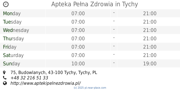
Apteka Pełna Zdrowia
Budowlanych 75, Tychy
Pharmacy
read more
15.758 km
Apteka im. I. Łukasiewicza s.c. Leki gotowe, recepturowe, homeopatia
Tysiąclecia 3, Wyry
Pharmacy
read more
17.93 km
Pharmacy At the Old Church
Stefana Okrzei 17, Mikołów
Pharmacy
read more
📑
all categories
Accounting
Administrative area level 1
Administrative area level 2
Airport
Amusement park
Aquarium
Art gallery
Atm
Bakery
Bank
Bar
Beauty salon
Bicycle store
Book store
Bowling alley
Bus station
Cafe
Campground
Car dealer
Car rental
Car repair
Car wash
Casino
Cemetery
Church
City hall
Clothing store
Colloquial area
Convenience store
Courthouse
Dentist
Department store
Doctor
Electrician
Electronics store
Embassy
Finance
Fire station
Florist
Food
Funeral home
Furniture store
Gas station
General contractor
Grocery or supermarket
Gym
Hair care
Hardware store
Health
Hindu Temple
Home goods store
Hospital
Insurance agency
Intersection
Jewelry store
Laundry
Lawyer
Library
Light rail station
Liquor store
Local government office
Locality
Locksmith
Lodging
Meal delivery
Meal takeaway
Mosque
Movie rental
Movie theater
Moving company
Museum
Natural feature
Neighborhood
Night club
Painter
Park
Parking
Pet store
Pharmacy
Physiotherapist
Place of worship
Plumber
Point of interest
Police
Political
Post office
Premise
Real estate agency
Restaurant
Roofing contractor
Route
Rv park, camping
School
Shoe store
Shopping mall
Spa
Stadium
Storage
Store
Subpremise
Subway station
Supermarket
Synagogue
Taxi stand
Train station
Transit station
Travel agency
University
Veterinary care
Zoo
administrative area level 3
sublocality level 1
↑