Park nearby Park AMENDY
Coronavirus disease (COVID-19) Situation
confirmed cases
6661991
deaths
120598
Poland
Park nearby Park AMENDY
Park AMENDY
Unnamed Road, Bytom Polska
contacts phone
:
+48
Latitude:
50.3268978
, Longitude:
18.9236996
read more
nearest Park
188 m
ROD Zygmunt
41-909 ul, Fabryczna, Bytom
Park
read more
813 m
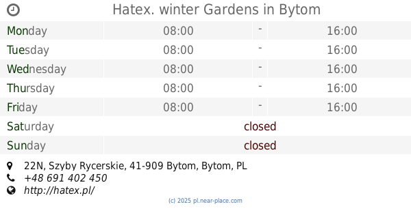
Hatex. winter Gardens
Szyby Rycerskie 22N, Bytom
Park
read more
858 m
Hatex. Ogrody zimowe
Szyby Rycerskie 22N, Bytom
Park
read more
953 m
Park Łagiewnicki
Bytom
Park
read more
1.087 km
Miejsce odpoczynku
Cicha 10b, Bytom
Park
read more
1.098 km
ODK Kamionka
Unnamed Road, Świętochłowice
Park
read more
1.167 km
Park im. A. Mickiewicza
Chorzowska 28H, Bytom
Park
read more
1.514 km
Szanta Klaudiusz Grochola Architektura Terenów Zielonych i Ogrodów; Usługi Ogrodnicze
Średnia 10C, Świętochłowice
Park
read more
1.538 km
Lasek Chropaczowski
Świętochłowice
Park
read more
1.538 km
Park Chropaczowski - Jedeek
Świętochłowice
Park
read more
1.617 km
Staw Pzw Nr 817
Chorzowska 29B, Bytom
Park
read more
1.657 km
Park Chropaczowski
Świętochłowice
Park
read more
1.922 km
ROD Niedurnego w Chorzowie
Chorzow
Park
read more
1.922 km
ROD Niedurnego w Chorzowie
Chorzów II, Chorzów
Park
read more
1.922 km
ROD Ziemia Ojczysta
Sienna, Bytom
Park
read more
1.927 km
Park Linowy
Frycza-Modrzewskiego, Bytom
Park
read more
2.088 km
wybieg dla psòw
Chorzow
Park
read more
2.221 km
Szynol
Bytom
Park
read more
2.234 km
Rodzinny Ogród Działkowy
Gruntowa, al.Słoneczników, Chorzów
Park
read more
2.492 km
Ogródki Działkowe Przyjaźń I
Siemianowicka 107, Bytom
Park
read more
2.917 km
Plac Targalskiego
Bytom
Park
read more
2.951 km
Aleja Marka Sienickiego
Unnamed Road, 41-902
Park
read more
3.028 km
Plac Niepodległości
Godula, 41-700
Park
read more
3.149 km
Park Miejski Kachla
Wrocławska 41-902, Bytom
Park
read more
3.17 km
Rzeźby Czapli
Bytom
Park
read more
📑
all categories
Accounting
Administrative area level 1
Administrative area level 2
Airport
Amusement park
Aquarium
Art gallery
Atm
Bakery
Bank
Bar
Beauty salon
Bicycle store
Book store
Bowling alley
Bus station
Cafe
Campground
Car dealer
Car rental
Car repair
Car wash
Casino
Cemetery
Church
City hall
Clothing store
Colloquial area
Convenience store
Courthouse
Dentist
Department store
Doctor
Electrician
Electronics store
Embassy
Finance
Fire station
Florist
Food
Funeral home
Furniture store
Gas station
General contractor
Grocery or supermarket
Gym
Hair care
Hardware store
Health
Hindu Temple
Home goods store
Hospital
Insurance agency
Intersection
Jewelry store
Laundry
Lawyer
Library
Light rail station
Liquor store
Local government office
Locality
Locksmith
Lodging
Meal delivery
Meal takeaway
Mosque
Movie rental
Movie theater
Moving company
Museum
Natural feature
Neighborhood
Night club
Painter
Park
Parking
Pet store
Pharmacy
Physiotherapist
Place of worship
Plumber
Point of interest
Police
Political
Post office
Premise
Real estate agency
Restaurant
Roofing contractor
Route
Rv park, camping
School
Shoe store
Shopping mall
Spa
Stadium
Storage
Store
Subpremise
Subway station
Supermarket
Synagogue
Taxi stand
Train station
Transit station
Travel agency
University
Veterinary care
Zoo
administrative area level 3
sublocality level 1
↑