Museum nearby Fosa miejska
Poland
Museum nearby Fosa miejska
Fosa miejska
67-200 Glogow, Poland
contacts phone
:
+48
Latitude:
51.6620812
, Longitude:
16.0885119
larger map & directions
read more
nearest Museum
313 m
Glogow
Unnamed Road, Głogów
Museum
read more
378 m
Sukiennice
Rynek, Głogów
Museum
read more
585 m
Muzeum Archeologiczno-Historyczne w Głogowie
Brama Brzostowska 1, Głogów
Museum
read more
705 m
Rampa przeładunkowa
Towarowa, Głogów
Museum
read more
1.053 km
Barbakan
Głogów
Museum
read more
1.621 km
Park przy fontannach
Unnamed Road, Głogów
Museum
read more
1.785 km
Głogów ul.Gołębia
Głogów
Museum
read more
1.94 km
Blue Tap
Kosmonautów Polskich 46, Głogów
Museum
read more
2.828 km
Skansen
Głogów
Museum
read more
3.16 km
Strzelnica Garnizonu Głogów
Poland
Museum
read more
24.14 km
Fontanna Witosławy
Rynek, Sława
Museum
read more
30.486 km
Plac Rynek
Rynek, Lubin
Museum
read more
30.523 km
Brenno
Wczasowa 4-6, Brenno
Museum
read more
34.995 km
Wloszakowice Zamek
Włoszakowice
Museum
read more
42.343 km
Ruiny Pałacu w Zatoniu
Zatonie
Museum
read more
46.14 km
Lpaqqyylyqylql
Kopernika 10-8
Museum
read more
49.083 km
Kamienna Zagroda
Ochla
Museum
read more
49.577 km
Ethnographic Museum in Zielona Gora. Headquarters
Muzealna 5, Ochla
Museum
read more
49.577 km
Muzeum Etnograficzne w Zielonej Górze-Ochli
Muzealna 5, Ochla
Museum
read more
49.926 km
Pomnik Zesłańców
59-216
Museum
read more
50.548 km
Lubuska Land Museum
aleja Niepodległości 15, Zielona Góra
Museum
read more
50.556 km
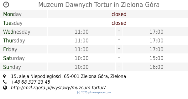
Muzeum Dawnych Tortur
aleja Niepodległości 15, Zielona Góra
Museum
read more
50.896 km
Muzeum Książki Środkowego Nadodrza
aleja Wojska Polskiego 9, Zielona Góra
Museum
read more
52.533 km
Ekspozycja wyposażenia dawnej cegielni.
Kamionkowa 2-4, Zielona Góra
Museum
read more
54.186 km
Schweinitz / Grünberg (nicht SchweiDnitz !!!!)
Długa 17, Świdnica
Museum
read more
📑
all categories
Accounting
Administrative area level 1
Administrative area level 2
Airport
Amusement park
Aquarium
Art gallery
Atm
Bakery
Bank
Bar
Beauty salon
Bicycle store
Book store
Bowling alley
Bus station
Cafe
Campground
Car dealer
Car rental
Car repair
Car wash
Casino
Cemetery
Church
City hall
Clothing store
Colloquial area
Convenience store
Courthouse
Dentist
Department store
Doctor
Electrician
Electronics store
Embassy
Finance
Fire station
Florist
Food
Funeral home
Furniture store
Gas station
General contractor
Grocery or supermarket
Gym
Hair care
Hardware store
Health
Hindu Temple
Home goods store
Hospital
Insurance agency
Intersection
Jewelry store
Laundry
Lawyer
Library
Light rail station
Liquor store
Local government office
Locality
Locksmith
Lodging
Meal delivery
Meal takeaway
Mosque
Movie rental
Movie theater
Moving company
Museum
Natural feature
Neighborhood
Night club
Painter
Park
Parking
Pet store
Pharmacy
Physiotherapist
Place of worship
Plumber
Point of interest
Police
Political
Post office
Premise
Real estate agency
Restaurant
Roofing contractor
Route
Rv park, camping
School
Shoe store
Shopping mall
Spa
Stadium
Storage
Store
Subpremise
Subway station
Supermarket
Synagogue
Taxi stand
Train station
Transit station
Travel agency
University
Veterinary care
Zoo
administrative area level 3
sublocality level 1
↑