Museum nearby Centre v
Coronavirus disease (COVID-19) Situation
confirmed cases
6661991
deaths
120598
Poland
Museum nearby Centre v
Centre v
Marszałkowska 98, Warszawa Polska
contacts phone
:
+48
Latitude:
52.2296756
, Longitude:
21.0122287
read more
nearest Museum
Palazzo Vilanow
10/16, via Potokiego, Warszawa
Museum
read more
38 m
WarsawOnline
Warszawa
Museum
read more
38 m
WarsawOnline
Warsaw
Museum
read more
274 m
Muzeum im. Bolesława Biegasa
00-697, Aleje Jerozolimskie 51, Warszawa
Museum
read more
437 m
Narodowe Muzeum Techniki
Pałac Kultury i Nauki 00-001, Warszawa
Museum
read more
488 m
Dollhouse Museum
plac Defilad 1, Warszawa
Museum
read more
525 m
Evolutionsmuseum
plac Defilad 1, Warszawa
Museum
read more
637 m
Galeria Piecowa przy Emilii Plater 47 pawilon15
Złota 1037, Warszawa
Museum
read more
673 m
Museum and Institute of Zoology PAS
Wilcza 64, Warszawa
Museum
read more
690 m
Museum of the Warsaw Geodesy Enterprise
Nowy Świat 2, Warszawa
Museum
read more
749 m
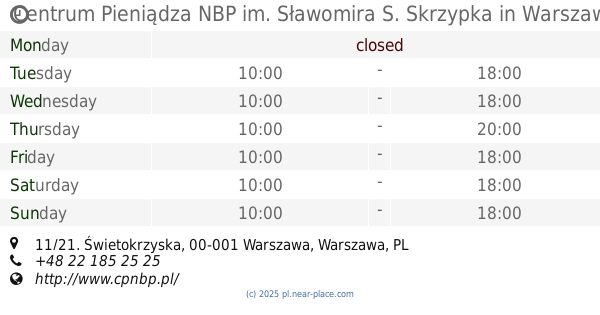
Centrum Pieniądza NBP
Świętokrzyska 11/21, Warszawa
Museum
read more
749 m
NBP Money Centre
Świętokrzyska 11/21, Warszawa
Museum
read more
749 m
Centrum Pieniądza NBP im. Sławomira S. Skrzypka
Świętokrzyska 11/21, Warszawa
Museum
read more
862 m
Menora InfoPunkt
plac Grzybowski 2, Warszawa
Museum
read more
882 m
Museo Nacional de Varsovia
Aleje Jerozolimskie 3, Warszawa
Museum
read more
882 m
Muzeum Narodowe w Warszawie
Aleje Jerozolimskie 3, Warszawa
Museum
read more
918 m
Guetto Building
Próżna 14, Warszawa
Museum
read more
944 m
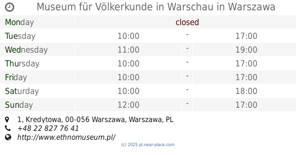
National Museum of Ethnography
Kredytowa 1, Warszawa
Museum
read more
944 m
Museum für Völkerkunde in Warschau
Kredytowa 1, Warszawa
Museum
read more
956 m
Muzeum Harcerstwa w Warszawie
Konopnickiej 6, Warszawa
Museum
read more
956 m
Museum of Scouting
Konopnickiej 6, Warszawa
Museum
read more
971 m
Muzeum Wojska Polskiego
Aleje Jerozolimskie 3, Warszawa
Museum
read more
971 m
Museum of the Polish Army
Aleje Jerozolimskie 3, Warszawa
Museum
read more
1.025 km
哥白尼广场
Śródmieście Północne, Warsaw
Museum
read more
1.176 km
Tablica pamiątkowa 1944
Unnamed Road
Museum
read more
📑
all categories
Accounting
Administrative area level 1
Administrative area level 2
Airport
Amusement park
Aquarium
Art gallery
Atm
Bakery
Bank
Bar
Beauty salon
Bicycle store
Book store
Bowling alley
Bus station
Cafe
Campground
Car dealer
Car rental
Car repair
Car wash
Casino
Cemetery
Church
City hall
Clothing store
Colloquial area
Convenience store
Courthouse
Dentist
Department store
Doctor
Electrician
Electronics store
Embassy
Finance
Fire station
Florist
Food
Funeral home
Furniture store
Gas station
General contractor
Grocery or supermarket
Gym
Hair care
Hardware store
Health
Hindu Temple
Home goods store
Hospital
Insurance agency
Intersection
Jewelry store
Laundry
Lawyer
Library
Light rail station
Liquor store
Local government office
Locality
Locksmith
Lodging
Meal delivery
Meal takeaway
Mosque
Movie rental
Movie theater
Moving company
Museum
Natural feature
Neighborhood
Night club
Painter
Park
Parking
Pet store
Pharmacy
Physiotherapist
Place of worship
Plumber
Point of interest
Police
Political
Post office
Premise
Real estate agency
Restaurant
Roofing contractor
Route
Rv park, camping
School
Shoe store
Shopping mall
Spa
Stadium
Storage
Store
Subpremise
Subway station
Supermarket
Synagogue
Taxi stand
Train station
Transit station
Travel agency
University
Veterinary care
Zoo
administrative area level 3
sublocality level 1
↑