Gas station nearby Shell
Poland
Gas station nearby Shell
Shell
87, aleja Wiśniowa, 53-126, Wrocław, Wrocław, PL Polska
contacts phone
:
+48 511 820 278
website:
find.shell.com
Latitude:
51.0834434
, Longitude:
17.02373
larger map & directions
read more
nearest Gas station
98 m
Orlen
Ślężna 88A, Wrocław
Gas station
read more
98 m
Stacja Paliw ORLEN
Ślężna 88A, Wrocław
Gas station
read more
144 m
Stacja Paliw ORLEN
Ślężna 129A, Wrocław
Gas station
read more
479 m
Shell
Ślężna 144, Wrocław
Gas station
read more
871 m
Lukoil
aleja Armii Krajowej 1, Wrocław
Gas station
read more
1.479 km
Shell
Powstańców Śląskich Krzycka, Wrocław
Gas station
read more
1.57 km
Shell
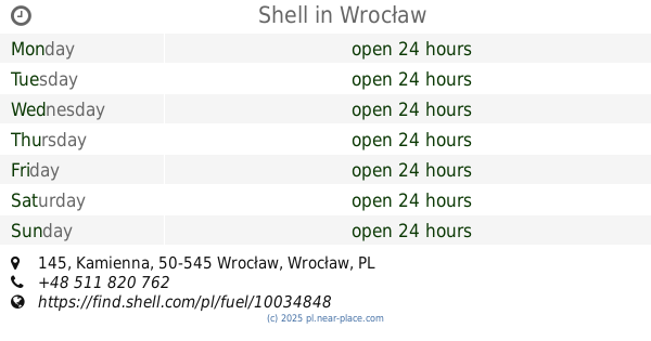
Kamienna 145, Wrocław
Gas station
read more
1.645 km
Автовокзал
Sucha 1, Wrocław
Gas station
read more
1.666 km
123 Statoil Wrocław
Hubska 102-118, Wrocław
Gas station
read more
1.668 km
Circle K
Hubska 102-118, Wrocław
Gas station
read more
1.668 km
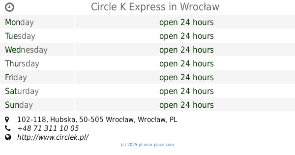
Circle K Express
Hubska 102-118, Wrocław
Gas station
read more
1.683 km
Lukoil
aleja Armii Krajowej 50, Wrocław
Gas station
read more
1.729 km
BP
Swobodna 60, Wrocław
Gas station
read more
1.816 km
Circle K
Sucha 15C, Wrocław
Gas station
read more
1.825 km
Auto
Swobodna, Wrocław
Gas station
read more
1.908 km
BP
Bardzka 26, Wrocław
Gas station
read more
2.218 km
Independent
Generała Kazimierza Pułaskiego 46, Wrocław
Gas station
read more
2.5 km
Pieprzyk
aleja Armii Krajowej 49, Wrocław
Gas station
read more
2.565 km
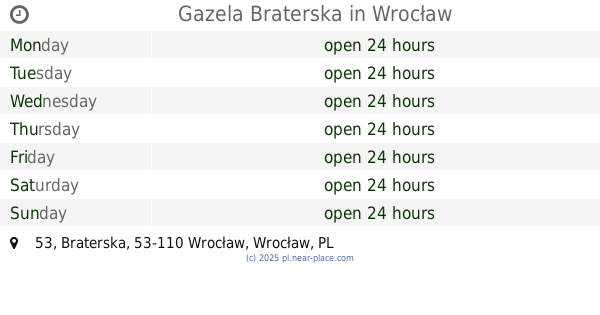
Gazela Braterska
Braterska 53, Wrocław
Gas station
read more
2.621 km
Stacja Paliw ORLEN
Tęczowa 5, Wrocław
Gas station
read more
2.63 km
Hor Mat s.c. Matelski M., Horski T.
Krakowska 1, Wrocław
Gas station
read more
2.654 km
BP
Krakowska 6-7, Wrocław
Gas station
read more
2.834 km
Circle K
aleja Karkonoska 52, Wrocław
Gas station
read more
2.878 km
Shell
Krakowska 70-80, Wrocław
Gas station
read more
2.968 km
Gazela
Krakowska 96, Wrocław
Gas station
read more
📑
all categories
Accounting
Administrative area level 1
Administrative area level 2
Airport
Amusement park
Aquarium
Art gallery
Atm
Bakery
Bank
Bar
Beauty salon
Bicycle store
Book store
Bowling alley
Bus station
Cafe
Campground
Car dealer
Car rental
Car repair
Car wash
Casino
Cemetery
Church
City hall
Clothing store
Colloquial area
Convenience store
Courthouse
Dentist
Department store
Doctor
Electrician
Electronics store
Embassy
Finance
Fire station
Florist
Food
Funeral home
Furniture store
Gas station
General contractor
Grocery or supermarket
Gym
Hair care
Hardware store
Health
Hindu Temple
Home goods store
Hospital
Insurance agency
Intersection
Jewelry store
Laundry
Lawyer
Library
Light rail station
Liquor store
Local government office
Locality
Locksmith
Lodging
Meal delivery
Meal takeaway
Mosque
Movie rental
Movie theater
Moving company
Museum
Natural feature
Neighborhood
Night club
Painter
Park
Parking
Pet store
Pharmacy
Physiotherapist
Place of worship
Plumber
Point of interest
Police
Political
Post office
Premise
Real estate agency
Restaurant
Roofing contractor
Route
Rv park, camping
School
Shoe store
Shopping mall
Spa
Stadium
Storage
Store
Subpremise
Subway station
Supermarket
Synagogue
Taxi stand
Train station
Transit station
Travel agency
University
Veterinary care
Zoo
administrative area level 3
sublocality level 1
↑