Gas station nearby Schell Tankstelle
Poland
Gas station nearby Schell Tankstelle
Schell Tankstelle
Parzęczew, Gmina Polska
contacts phone
:
+48
Latitude:
51.919438
, Longitude:
19.145136
read more
nearest Gas station
3.495 km
Stacja Paliw ORLEN
MOP Chrzastów Południe 17, A2, Parzęczew
Gas station
read more
18.834 km
Shell
Jana Kasprowicza 6/8, Zgierz
Gas station
read more
18.984 km
Czech-Oil Sp. z o.o.
Zagajnikowa 1, Dąbrówka Wielka
Gas station
read more
19.02 km
LOTOS Optima Rosanów
Zgierska 16 16, Rosanów
Gas station
read more
20.02 km
LPG Stacja
Szczecińska 28, Łódź
Gas station
read more
20.151 km
Independent
Szczecińska 6, Łódź
Gas station
read more
20.297 km
Stacja LPG
Słowiańska 153A, Antoniew
Gas station
read more
21.835 km
Stacja Paliw ORLEN
Długa 177, Zgierz
Gas station
read more
21.898 km
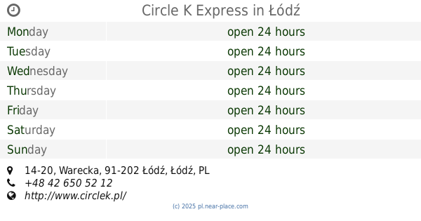
Circle K Express
Warecka 14-20, Łódź
Gas station
read more
22.314 km
Stacja Paliw D&D Warecka
Warecka 90, Łódź
Gas station
read more
23.744 km
Spółdzielnia Transportu Wiejskiego Stacja Paliw nr 3
Żniwna 4/8, Łódź
Gas station
read more
24.291 km
Circle K Express
ul, Łagiewnicka 215A, Łódź
Gas station
read more
25.916 km
Circle K
aleja Wyszyńskiego 27, Łódź
Gas station
read more
27.02 km
Orlen
Strykowska 38, Łódź
Gas station
read more
27.064 km
Lukoil
Łąkowa 23/25, Łódź
Gas station
read more
27.285 km
Independent
Aleja Jana Pawła 36, Łódź
Gas station
read more
27.484 km
Orlen
Obywatelska 181B, Łódź
Gas station
read more
27.67 km
BP ALFA
aleja Adama Mickiewicza 7, Łódź
Gas station
read more
27.67 km
BP
aleja Adama Mickiewicza 7, Łódź
Gas station
read more
29.085 km
Octane. Petrol station.
Tylna 7, Łódź
Gas station
read more
29.432 km
Petromax. PW. Kubiak R.
Słowiańska 1/9, Łódź
Gas station
read more
29.995 km
Interoil
Łęczycka 11/13, Łódź
Gas station
read more
30.988 km
Orlen
Śmigłego-Rydza 43, Łódź
Gas station
read more
33.209 km
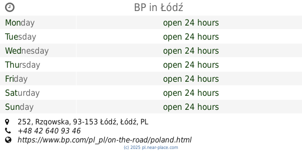
BP
Rzgowska 252, Łódź
Gas station
read more
33.302 km
AUTO GAZ
Kolumny 25, Łódź
Gas station
read more
📑
all categories
Accounting
Administrative area level 1
Administrative area level 2
Airport
Amusement park
Aquarium
Art gallery
Atm
Bakery
Bank
Bar
Beauty salon
Bicycle store
Book store
Bowling alley
Bus station
Cafe
Campground
Car dealer
Car rental
Car repair
Car wash
Casino
Cemetery
Church
City hall
Clothing store
Colloquial area
Convenience store
Courthouse
Dentist
Department store
Doctor
Electrician
Electronics store
Embassy
Finance
Fire station
Florist
Food
Funeral home
Furniture store
Gas station
General contractor
Grocery or supermarket
Gym
Hair care
Hardware store
Health
Hindu Temple
Home goods store
Hospital
Insurance agency
Intersection
Jewelry store
Laundry
Lawyer
Library
Light rail station
Liquor store
Local government office
Locality
Locksmith
Lodging
Meal delivery
Meal takeaway
Mosque
Movie rental
Movie theater
Moving company
Museum
Natural feature
Neighborhood
Night club
Painter
Park
Parking
Pet store
Pharmacy
Physiotherapist
Place of worship
Plumber
Point of interest
Police
Political
Post office
Premise
Real estate agency
Restaurant
Roofing contractor
Route
Rv park, camping
School
Shoe store
Shopping mall
Spa
Stadium
Storage
Store
Subpremise
Subway station
Supermarket
Synagogue
Taxi stand
Train station
Transit station
Travel agency
University
Veterinary care
Zoo
administrative area level 3
sublocality level 1
↑