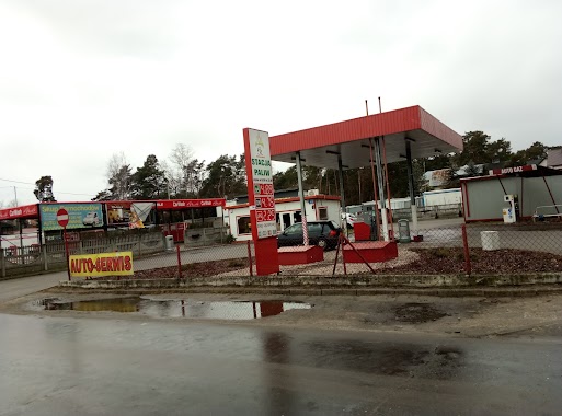
Gas station nearby Paliwo i LPG
Poland
Gas station nearby Paliwo i LPG
Paliwo i LPG
Osiecka, 05-430, otwocki, mazowieckie, PL Polska
contacts phone
:
+48
Latitude:
52.0566303
, Longitude:
21.3918561
larger map & directions
read more
nearest Gas station
5.315 km
Petrol Station ORLEN
1-go Maja 105, Kołbiel
Gas station
read more
5.318 km
Bliska Kołbiel
Maja 105 1, Kołbiel
Gas station
read more
7.245 km
BP
Gadka 120, Kołbiel
Gas station
read more
7.267 km
BP
DK17, Gadka
Gas station
read more
7.267 km
Stacja Paliw BP
DK17, Gadka
Gas station
read more
8.847 km
Stacja LPG
Karczew
Gas station
read more
9.09 km
Statoil
Szosa Lubelska 36, Otwock
Gas station
read more
9.162 km
чекатиму на заправці
Szosa Lubelska, Otwock
Gas station
read more
9.198 km
Andrasiak-Czarnecka sp.j.
Wspaniała 2, Otwock
Gas station
read more
10.277 km
A. R. Stacja Paliw
Samorządowa 43, Otwock
Gas station
read more
10.282 km
NIEZRZESZONA - Otwock
Samorządowa 40, Otwock
Gas station
read more
10.409 km
Circle K
ul, Kołbielska 36, Grębiszew
Gas station
read more
10.7 km
Petrol Station Wasbruk
Świderska 36, Karczew
Gas station
read more
12.205 km
Lotos
Sosnowa 11, Maliszew
Gas station
read more
12.205 km
LOTOS Optima. Stacja paliw.
Sosnowa 11, Maliszew
Gas station
read more
12.899 km
Stacja Paliw ORLEN
aleja Nadwiślańska 5, Józefów
Gas station
read more
13.679 km
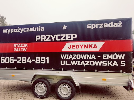
Stacja paliw, Wypożyczalnia Przyczep - Łysik T. Autogaz.
Wiązowska 5, Emów
Gas station
read more
13.904 km
Troja
Józefów
Gas station
read more
15.067 km
Stacja Paliw
Mińska 2, Pogorzel
Gas station
read more
15.084 km
Independent
Droga Wojewódzka 739 8
Gas station
read more
15.634 km
Stacja Paliw Pegas Grupa
Wojska Polskiego 37, Góra Kalwaria
Gas station
read more
15.67 km
E 100
Wojska Polskiego 37, Góra Kalwaria
Gas station
read more
15.859 km
Stacja Paliw ORLEN
Rybie 4, Góra Kalwaria
Gas station
read more
16.723 km
Barter
Patriotów 45, Warszawa
Gas station
read more
17.622 km
Car Wash - Myjnia Ręczna Samochodowa
Warszawska 38, Stojadła
Gas station
read more
📑
all categories
Accounting
Administrative area level 1
Administrative area level 2
Airport
Amusement park
Aquarium
Art gallery
Atm
Bakery
Bank
Bar
Beauty salon
Bicycle store
Book store
Bowling alley
Bus station
Cafe
Campground
Car dealer
Car rental
Car repair
Car wash
Casino
Cemetery
Church
City hall
Clothing store
Colloquial area
Convenience store
Courthouse
Dentist
Department store
Doctor
Electrician
Electronics store
Embassy
Finance
Fire station
Florist
Food
Funeral home
Furniture store
Gas station
General contractor
Grocery or supermarket
Gym
Hair care
Hardware store
Health
Hindu Temple
Home goods store
Hospital
Insurance agency
Intersection
Jewelry store
Laundry
Lawyer
Library
Light rail station
Liquor store
Local government office
Locality
Locksmith
Lodging
Meal delivery
Meal takeaway
Mosque
Movie rental
Movie theater
Moving company
Museum
Natural feature
Neighborhood
Night club
Painter
Park
Parking
Pet store
Pharmacy
Physiotherapist
Place of worship
Plumber
Point of interest
Police
Political
Post office
Premise
Real estate agency
Restaurant
Roofing contractor
Route
Rv park, camping
School
Shoe store
Shopping mall
Spa
Stadium
Storage
Store
Subpremise
Subway station
Supermarket
Synagogue
Taxi stand
Train station
Transit station
Travel agency
University
Veterinary care
Zoo
administrative area level 3
sublocality level 1
↑