Gas station nearby AUTO GAZ
Poland
Gas station nearby AUTO GAZ
AUTO GAZ
Kadetów, Warszawa Polska
contacts phone
:
+48
Latitude:
52.2144232
, Longitude:
21.1348253
read more
nearest Gas station
5 m
Stacja LPG - Warszawa
Lucerny 3/11, Warszawa
Gas station
read more
1.571 km
Wasbruk
Białoborska 4, Warszawa
Gas station
read more
1.604 km
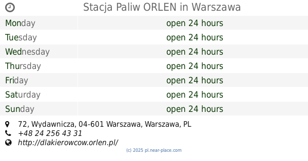
Stacja Paliw ORLEN
Wydawnicza 72, Warszawa
Gas station
read more
1.604 km
Petrol Station ORLEN
Wydawnicza 72, Warszawa
Gas station
read more
2.146 km
Shell
Korkowa 2, Warszawa
Gas station
read more
2.198 km
MOYA
Rzeźbiarska 3, Warszawa
Gas station
read more
2.41 km
Shell
Ostrobramska 75, Warszawa
Gas station
read more
2.426 km
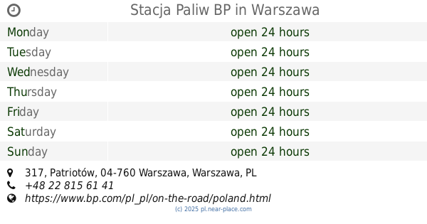
Stacja Paliw BP
Patriotów 317, Warszawa
Gas station
read more
2.426 km
BP
Patriotów 317, Warszawa
Gas station
read more
2.56 km
Orlen
Trakt Lubelski 154, Warszawa
Gas station
read more
2.611 km
Stacja Paliw ORLEN
Konopna 11, Warszawa
Gas station
read more
2.611 km
Petrol Station ORLEN
Konopna 11, Warszawa
Gas station
read more
2.727 km
Circle K
Grochowska 19, Warszawa
Gas station
read more
3.033 km
Stacja Paliw BP
Wał Miedzeszyński 670, Warszawa
Gas station
read more
3.033 km
BP
Wał Miedzeszyński 670, Warszawa
Gas station
read more
3.051 km
Circle K
Jugosłowiańska 19, Warszawa
Gas station
read more
3.185 km
BP
Ostrobramska 81, Warszawa
Gas station
read more
3.288 km
Stacja paliw LPG Auto GAZ
Fieldorfa 207, Warszawa
Gas station
read more
3.338 km
Stacja Paliw
Korkowa 161, Warszawa
Gas station
read more
3.347 km
Stacja Paliw BP Dolina
Gen. Fieldorfa 41A Augusta Emila, Warszawa
Gas station
read more
3.347 km
BP
Gen. Fieldorfa 41A Augusta Emila, Warszawa
Gas station
read more
3.353 km
Заправка
Gen. Fieldorfa 41A, Warszawa
Gas station
read more
3.434 km
Myjnia Bezdotykowa Speed Wash S.C. 81a
Jana Nowaka-Jeziorańskiego 81a, Warszawa
Gas station
read more
3.781 km
AXAN Sp. z o.o.
ul. A, Okuniewska 6, Warszawa
Gas station
read more
3.781 km
Axana Sp. o.o.
ul. A, Okuniewska 6, Warszawa
Gas station
read more
📑
all categories
Accounting
Administrative area level 1
Administrative area level 2
Airport
Amusement park
Aquarium
Art gallery
Atm
Bakery
Bank
Bar
Beauty salon
Bicycle store
Book store
Bowling alley
Bus station
Cafe
Campground
Car dealer
Car rental
Car repair
Car wash
Casino
Cemetery
Church
City hall
Clothing store
Colloquial area
Convenience store
Courthouse
Dentist
Department store
Doctor
Electrician
Electronics store
Embassy
Finance
Fire station
Florist
Food
Funeral home
Furniture store
Gas station
General contractor
Grocery or supermarket
Gym
Hair care
Hardware store
Health
Hindu Temple
Home goods store
Hospital
Insurance agency
Intersection
Jewelry store
Laundry
Lawyer
Library
Light rail station
Liquor store
Local government office
Locality
Locksmith
Lodging
Meal delivery
Meal takeaway
Mosque
Movie rental
Movie theater
Moving company
Museum
Natural feature
Neighborhood
Night club
Painter
Park
Parking
Pet store
Pharmacy
Physiotherapist
Place of worship
Plumber
Point of interest
Police
Political
Post office
Premise
Real estate agency
Restaurant
Roofing contractor
Route
Rv park, camping
School
Shoe store
Shopping mall
Spa
Stadium
Storage
Store
Subpremise
Subway station
Supermarket
Synagogue
Taxi stand
Train station
Transit station
Travel agency
University
Veterinary care
Zoo
administrative area level 3
sublocality level 1
↑