Cafe nearby Czerwone Pióro
Poland
Cafe nearby Czerwone Pióro
Czerwone Pióro
Święty Marcin 39, Poznań Polen
contacts phone
:
+48
Latitude:
52.4068771
, Longitude:
16.9220679
read more
nearest Cafe
153 m
Jadłodajnia Caritas Archidiecezji Poznańskiej
Taczaka 7, Poznań
Cafe
read more
214 m
Bo Poznan
Kościuszki 84, Poznań
Cafe
read more
274 m
Evelyn Cafe
Powstańców Wielkopolskich 2a, Poznań
Cafe
read more
295 m
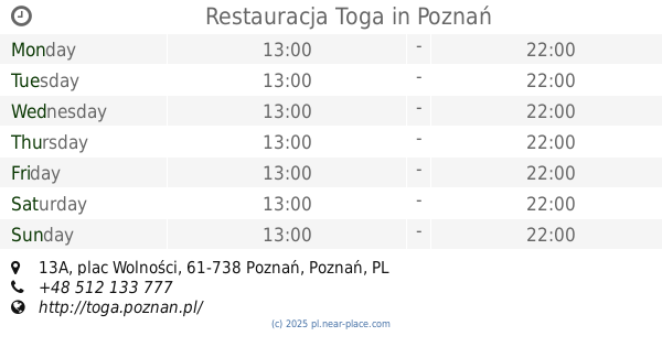
Restauracja Toga
plac Wolności 13A, Poznań
Cafe
read more
378 m
Kocimiętka
Ratajczaka 18, Poznań
Cafe
read more
391 m
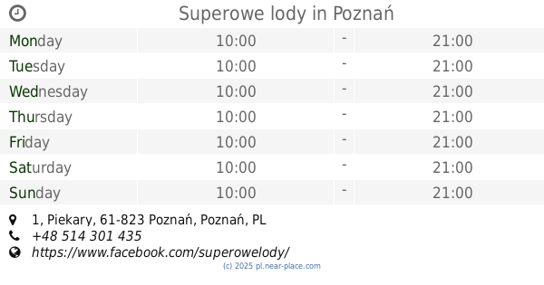
Superowe lody
Piekary 1, Poznań
Cafe
read more
446 m
Bike Cafe
plac Wolności 1, Poznań
Cafe
read more
447 m
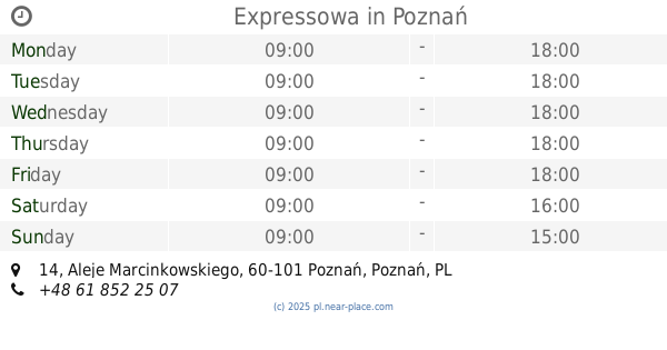
Expressowa
Aleje Marcinkowskiego 14, Poznań
Cafe
read more
526 m
Cukiernia Karpicko
Półwiejska 42, Poznań
Cafe
read more
584 m
Ciastkarnia
Krysiewicza 6, Poznań
Cafe
read more
640 m
Grycan
C.H. Kupiec Poznański, Pl. Wiosny Ludów 2, Poznań
Cafe
read more
655 m
Gruszecki. Kawiarnia, bistro
plac Wiosny Ludów 2, Poznań
Cafe
read more
688 m
Artisan Poznań
Szkolna 9, Poznań
Cafe
read more
722 m
Bistro Trio
Porucznika Janiny Lewandowskiej 36, Poznań
Cafe
read more
732 m
Fudge Filosophy
Długa 9/1, Poznań
Cafe
read more
736 m
Słodkie Czary Mary Poznań
Wrocławska 12, Poznań
Cafe
read more
748 m
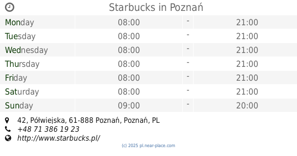
Starbucks
Stary Browar, Półwiejska 42, Poznań
Cafe
read more
762 m
W Filizance Cafe Poznań
Wrocławska 15, Poznań
Cafe
read more
764 m
GLANC
Zwierzyniecka 3, Poznań
Cafe
read more
778 m
Siesta
Półwiejska 41, Poznań
Cafe
read more
796 m
Cafe Isabela
Stary Rynek 57, Poznań
Cafe
read more
852 m
Kawiarnia Arkady
Stary Rynek 52, Poznań
Cafe
read more
856 m
Cafe Dylemat
Mickiewicza 27, Poznań
Cafe
read more
966 m
Sofa Cafe & Lunch
Żydowska 30, Poznań
Cafe
read more
1.059 km
Marina. Lody Molekularne.
Dąbrowskiego 29, Poznań
Cafe
read more
📑
all categories
Accounting
Administrative area level 1
Administrative area level 2
Airport
Amusement park
Aquarium
Art gallery
Atm
Bakery
Bank
Bar
Beauty salon
Bicycle store
Book store
Bowling alley
Bus station
Cafe
Campground
Car dealer
Car rental
Car repair
Car wash
Casino
Cemetery
Church
City hall
Clothing store
Colloquial area
Convenience store
Courthouse
Dentist
Department store
Doctor
Electrician
Electronics store
Embassy
Finance
Fire station
Florist
Food
Funeral home
Furniture store
Gas station
General contractor
Grocery or supermarket
Gym
Hair care
Hardware store
Health
Hindu Temple
Home goods store
Hospital
Insurance agency
Intersection
Jewelry store
Laundry
Lawyer
Library
Light rail station
Liquor store
Local government office
Locality
Locksmith
Lodging
Meal delivery
Meal takeaway
Mosque
Movie rental
Movie theater
Moving company
Museum
Natural feature
Neighborhood
Night club
Painter
Park
Parking
Pet store
Pharmacy
Physiotherapist
Place of worship
Plumber
Point of interest
Police
Political
Post office
Premise
Real estate agency
Restaurant
Roofing contractor
Route
Rv park, camping
School
Shoe store
Shopping mall
Spa
Stadium
Storage
Store
Subpremise
Subway station
Supermarket
Synagogue
Taxi stand
Train station
Transit station
Travel agency
University
Veterinary care
Zoo
administrative area level 3
sublocality level 1
↑