Cafe nearby COSTA COFFEE
Coronavirus disease (COVID-19) Situation
confirmed cases
6661991
deaths
120598
Poland
Cafe nearby COSTA COFFEE
COSTA COFFEE
al. Zwycięstwa 256, CH Klif, 81-525 Gdynia, Polska
contacts phone
:
+48 58 668 49 96
website:
www.costacoffee.pl
Latitude:
54.4747181
, Longitude:
18.5522432
larger map & directions
read more
nearest Cafe
43 m
COSTA COFFEE
aleja Zwycięstwa 256, Gdynia
Cafe
read more
50 m
SO! COFFEE
CH Klif, ul. Zwycięstwa 256, Gdynia
Cafe
read more
50 m
Ristorante Como
aleja Zwycięstwa 256, Gdynia
Cafe
read more
109 m
Lili's Coffee
aleja Zwycięstwa 256, Gdynia
Cafe
read more
109 m
Lili's Coffee -Klif
aleja Zwycięstwa 256, Gdynia
Cafe
read more
603 m
DeguStacja
Inżynierska 95, Gdynia
Cafe
read more
773 m
deguStacja - Cafe and Gallery
Architektów 1A, Gdynia
Cafe
read more
1.595 km
Kawiarnia Capuccino Cafe
Aleja Niepodległości 899, Sopot
Cafe
read more
1.708 km
Costa Express
Aleja Niepodległości 897, Sopot
Cafe
read more
2.554 km
Deserownia
Legionów 107B, Gdynia
Cafe
read more
3.371 km
Sopot Molo
Sopot
Cafe
read more
3.384 km
Topos Cafe
Aleja Niepodległości 804A, Sopot
Cafe
read more
3.427 km
Młody Byron - kawiarnia artystyczna
Józefa Czyżewskiego 12, Sopot
Cafe
read more
3.427 km
Cafe Kultura
Królowej Jadwigi 7, Sopot
Cafe
read more
3.481 km
Grycan
C.H. Gdynia Riviera, ul. Kazimierza Górskiego 2, Gdynia
Cafe
read more
3.524 km
projektowa
Obrońców Westerplatte 2-4, Sopot
Cafe
read more
3.57 km
La Crema d'Italia
14, Bohaterów Monte Cassino, Sopot
Cafe
read more
3.829 km
Cafe Impresja
Fryderyka Chopina 26, Sopot
Cafe
read more
4.07 km
Moher Cafe
Ignacego Krasickiego 6, Gdynia
Cafe
read more
4.209 km
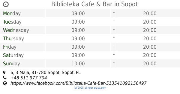
Biblioteka Cafe & Bar
3 Maja 6, Sopot
Cafe
read more
4.47 km
Leśna kawiarnia
Świętojańska 61/1, Gdynia
Cafe
read more
4.558 km
Contrast Cafe
Bulwar Nadmorski im.Feliksa Nowowiejskiego, Gdynia
Cafe
read more
4.678 km
Milopol
Antoniego Abrahama, Gdynia
Cafe
read more
4.993 km
Mariola Cafe
10 Lutego 11, Gdynia
Cafe
read more
5.335 km
Gofry I Lody
Karlikowo, Sopot
Cafe
read more
📑
all categories
Accounting
Administrative area level 1
Administrative area level 2
Airport
Amusement park
Aquarium
Art gallery
Atm
Bakery
Bank
Bar
Beauty salon
Bicycle store
Book store
Bowling alley
Bus station
Cafe
Campground
Car dealer
Car rental
Car repair
Car wash
Casino
Cemetery
Church
City hall
Clothing store
Colloquial area
Convenience store
Courthouse
Dentist
Department store
Doctor
Electrician
Electronics store
Embassy
Finance
Fire station
Florist
Food
Funeral home
Furniture store
Gas station
General contractor
Grocery or supermarket
Gym
Hair care
Hardware store
Health
Hindu Temple
Home goods store
Hospital
Insurance agency
Intersection
Jewelry store
Laundry
Lawyer
Library
Light rail station
Liquor store
Local government office
Locality
Locksmith
Lodging
Meal delivery
Meal takeaway
Mosque
Movie rental
Movie theater
Moving company
Museum
Natural feature
Neighborhood
Night club
Painter
Park
Parking
Pet store
Pharmacy
Physiotherapist
Place of worship
Plumber
Point of interest
Police
Political
Post office
Premise
Real estate agency
Restaurant
Roofing contractor
Route
Rv park, camping
School
Shoe store
Shopping mall
Spa
Stadium
Storage
Store
Subpremise
Subway station
Supermarket
Synagogue
Taxi stand
Train station
Transit station
Travel agency
University
Veterinary care
Zoo
administrative area level 3
sublocality level 1
↑