Cafe nearby Cafe Cool & Cafe Diesel
Poland
Cafe nearby Cafe Cool & Cafe Diesel
Cafe Cool & Cafe Diesel
Trzech Stawów, 40-289, Katowice, Katowice, PL Polska
contacts phone
:
+48
website:
www.facebook.com
Latitude:
50.2413227
, Longitude:
19.0468708
larger map & directions
read more
nearest Cafe
725 m
Lodomania
Pułaskiego 60, Katowice
Cafe
read more
761 m
Cafe Chopin. Kawiarnia
Pułaskiego 60, Katowice
Cafe
read more
778 m
coffee-jka
Prowansalska 27, Katowice
Cafe
read more
1.756 km
I Coffee. Kawiarnia
Przemysłowa 3, Katowice
Cafe
read more
1.936 km
Robertino
Francuska 35, Katowice
Cafe
read more
1.945 km
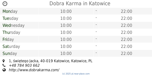
Dobra Karma
świętego Jacka 1, Katowice
Cafe
read more
2.087 km
Herbaciarnia Smoczy Czajnik
Francuska 15, Katowice
Cafe
read more
2.148 km
Coffee Ways
Mariacka 37, Katowice
Cafe
read more
2.2 km
Botanika
Sienkiewicza 27, Katowice
Cafe
read more
2.267 km
Social Cooperative DeKato
Warszawska 28, Katowice
Cafe
read more
2.326 km
Chimney Sweep Shisha Pub
Wojewódzka 24, Katowice
Cafe
read more
2.346 km
Lorneta z Meduzą
Mariacka 5, Katowice
Cafe
read more
2.354 km
3 Sisters Bagel and Coffee
Świętego Stanisława 8, Katowice
Cafe
read more
2.38 km
Bajderka
Warszawska 21/2, Katowice
Cafe
read more
2.41 km
Fanaberia
Wita Stwosza 6, Katowice
Cafe
read more
2.421 km
Fanaberia Tea Garden
Wita Stwosza 6, Katowice
Cafe
read more
2.433 km
Subway
Mielęckiego 10, Katowice
Cafe
read more
2.536 km
Cafe Chopin
Dyrekcyjna 6, Katowice
Cafe
read more
2.554 km
Teoria – kluboczajownia
Dworcowa 13, Katowice
Cafe
read more
2.56 km
Ignacy Pawłowski
Dworcowa 13, Katowice
Cafe
read more
2.56 km
Kluboczajownia Teoria
Dworcowa 13, Katowice
Cafe
read more
2.591 km
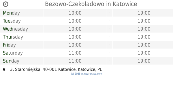
Bezowo-Czekoladowo
Staromiejska 3, Katowice
Cafe
read more
2.619 km
Cukiernia Europejska
Rynek 12, Katowice
Cafe
read more
2.636 km
Kawiarnia na kołach
Świętego Jana, Katowice
Cafe
read more
2.773 km
Bez Cukru
Wawelska 1, Katowice
Cafe
read more
📑
all categories
Accounting
Administrative area level 1
Administrative area level 2
Airport
Amusement park
Aquarium
Art gallery
Atm
Bakery
Bank
Bar
Beauty salon
Bicycle store
Book store
Bowling alley
Bus station
Cafe
Campground
Car dealer
Car rental
Car repair
Car wash
Casino
Cemetery
Church
City hall
Clothing store
Colloquial area
Convenience store
Courthouse
Dentist
Department store
Doctor
Electrician
Electronics store
Embassy
Finance
Fire station
Florist
Food
Funeral home
Furniture store
Gas station
General contractor
Grocery or supermarket
Gym
Hair care
Hardware store
Health
Hindu Temple
Home goods store
Hospital
Insurance agency
Intersection
Jewelry store
Laundry
Lawyer
Library
Light rail station
Liquor store
Local government office
Locality
Locksmith
Lodging
Meal delivery
Meal takeaway
Mosque
Movie rental
Movie theater
Moving company
Museum
Natural feature
Neighborhood
Night club
Painter
Park
Parking
Pet store
Pharmacy
Physiotherapist
Place of worship
Plumber
Point of interest
Police
Political
Post office
Premise
Real estate agency
Restaurant
Roofing contractor
Route
Rv park, camping
School
Shoe store
Shopping mall
Spa
Stadium
Storage
Store
Subpremise
Subway station
Supermarket
Synagogue
Taxi stand
Train station
Transit station
Travel agency
University
Veterinary care
Zoo
administrative area level 3
sublocality level 1
↑