Bar nearby The Leaders Pub
Poland
Bar nearby The Leaders Pub
The Leaders Pub
Starowiejska 2, Poznań Polska
contacts phone
:
+48
Latitude:
52.427331
, Longitude:
16.9243993
read more
nearest Bar
8 m
Szybka Bila
Starowiejska 2, Poznań
Bar
read more
261 m
Catering - Bar ASK
os. Przyjażni 132 a - c, Pawilon 2a, Poznań
Bar
read more
567 m
9 stóp
Piątkowska 92, Poznań
Bar
read more
1.722 km
Winelove
Święty Wojciech 7/1, Poznań
Bar
read more
1.795 km
Barek
Juraszów 7/19, Poznań
Bar
read more
1.82 km
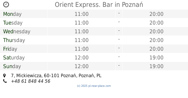
Orient Express. Bar
Mickiewicza 7, Poznań
Bar
read more
1.959 km
Nowy Franklin
Roosevelta 10, Poznań
Bar
read more
1.979 km
Pub „Elizjum”
Nowowiejskiego 10/1a, Poznań
Bar
read more
1.979 km
“Elizjum" Pub
Nowowiejskiego 10/1a, Poznań
Bar
read more
1.992 km
The Old Cinema
Nowowiejskiego 8, Poznań
Bar
read more
1.992 km
W Starym Kinie
Nowowiejskiego 8, Poznań
Bar
read more
1.996 km
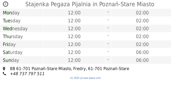
Stajenka Pegaza Pijalnia
Fredry 8B 61-701 Poznań-Stare Miasto, Poznań-Stare Miasto
Bar
read more
2.016 km
Ministerstwo Browaru
Wroniecka 16, Poznań
Bar
read more
2.017 km
MAD MAX Reaktywacja Pub
Poznańska 8, Poznań
Bar
read more
2.033 km
Chmielnik
Żydowska 27, Poznań
Bar
read more
2.058 km
Dom Piwa multi-tap
2, Mokra 2, Poznań
Bar
read more
2.069 km
Peryskop Ogród
Szewska 8, Poznań
Bar
read more
2.069 km
PRL
Żydowska 11, Poznań
Bar
read more
2.075 km
Tanner's Irish Pub
Wroniecka 21, Poznań
Bar
read more
2.08 km
Rock Garaż
Szewska, Poznań
Bar
read more
2.111 km
Lot Chmiela
Żydowska 4, Poznań
Bar
read more
2.436 km
Wine & Friends
Szamarzewskiego 2, Poznań
Bar
read more
2.444 km
#StacjaUrbano
#StacjaUrbano #Wawrzyniala19, Poznań
Bar
read more
2.448 km
STACJA URBANO
Wawrzyniaka 19, Poznań
Bar
read more
2.601 km
Konkret
Szamarzewskiego 37, Poznań
Bar
read more
📑
all categories
Accounting
Administrative area level 1
Administrative area level 2
Airport
Amusement park
Aquarium
Art gallery
Atm
Bakery
Bank
Bar
Beauty salon
Bicycle store
Book store
Bowling alley
Bus station
Cafe
Campground
Car dealer
Car rental
Car repair
Car wash
Casino
Cemetery
Church
City hall
Clothing store
Colloquial area
Convenience store
Courthouse
Dentist
Department store
Doctor
Electrician
Electronics store
Embassy
Finance
Fire station
Florist
Food
Funeral home
Furniture store
Gas station
General contractor
Grocery or supermarket
Gym
Hair care
Hardware store
Health
Hindu Temple
Home goods store
Hospital
Insurance agency
Intersection
Jewelry store
Laundry
Lawyer
Library
Light rail station
Liquor store
Local government office
Locality
Locksmith
Lodging
Meal delivery
Meal takeaway
Mosque
Movie rental
Movie theater
Moving company
Museum
Natural feature
Neighborhood
Night club
Painter
Park
Parking
Pet store
Pharmacy
Physiotherapist
Place of worship
Plumber
Point of interest
Police
Political
Post office
Premise
Real estate agency
Restaurant
Roofing contractor
Route
Rv park, camping
School
Shoe store
Shopping mall
Spa
Stadium
Storage
Store
Subpremise
Subway station
Supermarket
Synagogue
Taxi stand
Train station
Transit station
Travel agency
University
Veterinary care
Zoo
administrative area level 3
sublocality level 1
↑