Bar nearby Pub Mateusz
Poland
Bar nearby Pub Mateusz
Pub Mateusz
Miodowa 10A, Ruda Śląska Polen
contacts phone
:
+48
Latitude:
50.2408389
, Longitude:
18.836401
read more
nearest Bar
286 m
Balaton. Pub
Solidarności 7, Ruda Śląska
Bar
read more
302 m
Pub No i fajnie
Młyńska 3, Ruda Śląska
Bar
read more
499 m
Ministry Herring and vodka
Kłodnicka 97, Ruda Śląska
Bar
read more
499 m
Ministerstwo Śledzia i Wódki
Kłodnicka 97, Ruda Śląska
Bar
read more
908 m
Pub Alibi
Solidarności 23, Ruda Śląska
Bar
read more
928 m
Bar Kamil
Solidarności 23, Ruda Śląska
Bar
read more
1.747 km
Majmax
Nowa 2, Ruda Śląska
Bar
read more
2.162 km
Bar u Asi.
Wawrzyńca Szczudlaka 76, Ruda Śląska
Bar
read more
3.896 km
Zajazd "Amazonka"
Kokota 58, Ruda Śląska
Bar
read more
4.064 km
Słowik
Krasińskiego 4, Ruda Śląska
Bar
read more
4.067 km
Pod Łososiem
Teatralna 5c, Ruda Śląska
Bar
read more
4.179 km
Duet. Bar piwny
Fryderyka Joliot-Curie 3, Ruda Śląska
Bar
read more
4.18 km
Bar DUET
Fryderyka Joliot-Curie 3A, Ruda Śląska
Bar
read more
4.183 km
BAR
Sienkiewicza 10A, Ruda Śląska
Bar
read more
4.394 km
Mr. Hamburger
1 Maja 310, Ruda Śląska
Bar
read more
4.583 km
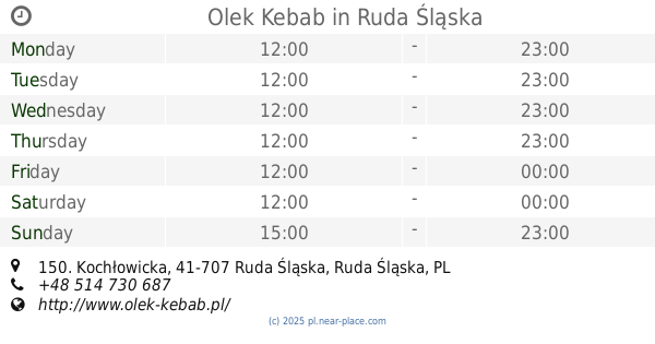
Olek Kebab
Kochłowicka 150, Ruda Śląska
Bar
read more
4.863 km
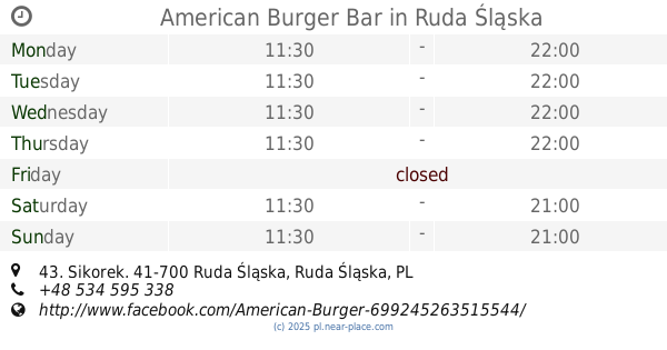
American Burger Bar
Sikorek 43, Ruda Śląska
Bar
read more
5.229 km
Młody Gluś
11 Listopada 7, Ruda Śląska
Bar
read more
5.24 km
City Pub
Kopalniana 1, Ruda Śląska
Bar
read more
5.247 km
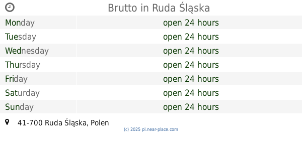
Brutto
Ruda Slaska
Bar
read more
5.366 km
bistro przy kachloku
Ks. Potyki 24, Ruda Śląska
Bar
read more
5.366 km
bistro przy kachloku
24 Ks, Potyki, Ruda Śląska
Bar
read more
5.472 km
Knefel
Czarnoleśna, Ruda Śląska
Bar
read more
5.499 km
Wieża. Bar piwny
Jana Furgoła 2, Ruda Śląska
Bar
read more
9.039 km
Desperado
Armii Krajowej, Chorzów
Bar
read more
📑
all categories
Accounting
Administrative area level 1
Administrative area level 2
Airport
Amusement park
Aquarium
Art gallery
Atm
Bakery
Bank
Bar
Beauty salon
Bicycle store
Book store
Bowling alley
Bus station
Cafe
Campground
Car dealer
Car rental
Car repair
Car wash
Casino
Cemetery
Church
City hall
Clothing store
Colloquial area
Convenience store
Courthouse
Dentist
Department store
Doctor
Electrician
Electronics store
Embassy
Finance
Fire station
Florist
Food
Funeral home
Furniture store
Gas station
General contractor
Grocery or supermarket
Gym
Hair care
Hardware store
Health
Hindu Temple
Home goods store
Hospital
Insurance agency
Intersection
Jewelry store
Laundry
Lawyer
Library
Light rail station
Liquor store
Local government office
Locality
Locksmith
Lodging
Meal delivery
Meal takeaway
Mosque
Movie rental
Movie theater
Moving company
Museum
Natural feature
Neighborhood
Night club
Painter
Park
Parking
Pet store
Pharmacy
Physiotherapist
Place of worship
Plumber
Point of interest
Police
Political
Post office
Premise
Real estate agency
Restaurant
Roofing contractor
Route
Rv park, camping
School
Shoe store
Shopping mall
Spa
Stadium
Storage
Store
Subpremise
Subway station
Supermarket
Synagogue
Taxi stand
Train station
Transit station
Travel agency
University
Veterinary care
Zoo
administrative area level 3
sublocality level 1
↑