Bar nearby Pijalnia BANG
Poland
Bar nearby Pijalnia BANG
Pijalnia BANG
18, Leśna, 25-001, Kielce, Kielce, PL Polska
contacts phone
:
+48 504 113 334
website:
mobile.facebook.com
Latitude:
50.8715266
, Longitude:
20.6278035
larger map & directions
read more
nearest Bar
165 m
Ukraińska Kuchnia
37, Henryka Sienkiewicza, Kielce
Bar
read more
165 m
Ukraińska Kuchnia
Henryka Sienkiewicza 37, Kielce
Bar
read more
228 m
Craft Beer PUB
Piotrkowska 2, Kielce
Bar
read more
229 m
Face Burger
Piotrkowska 2, Kielce
Bar
read more
238 m
Plejada Restaurant&Pub
Rynek 16, Kielce
Bar
read more
262 m
Klubokawiarnia Quest
Duża 7, Kielce
Bar
read more
268 m
Quick Buffet
Ignacego Paderewskiego 34a/1, Kielce
Bar
read more
292 m
Siesta Ristorante e Bar
Rynek 12, Kielce
Bar
read more
294 m
Piwnica
Świętego Leonarda 23/9, Kielce
Bar
read more
307 m
Centralny Bar Mleczny
Henryka Sienkiewicza 13, Kielce
Bar
read more
338 m
Irish Pub
Ignacego Paderewskiego 27, Kielce
Bar
read more
350 m
Zamkowe Tarasy
Zamkowa 4, Kielce
Bar
read more
376 m
West Side
Świętego Leonarda 16, Kielce
Bar
read more
377 m
Przystanek
Bodzentyńska 3, Kielce
Bar
read more
383 m
Bar Prosiaczek
Świętego Leonarda 15, Kielce
Bar
read more
415 m
Renament Gastrobar
Świętego Leonarda 11, Kielce
Bar
read more
423 m
Tapas
Wesoła 10, Kielce
Bar
read more
423 m
Atmosfera. Pub
Wesoła 9, Kielce
Bar
read more
553 m
Pizza Pub Ghiootto
25-001, Żytnia 6, Kielce
Bar
read more
581 m
Woor
plac Wolności 1, Kielce
Bar
read more
646 m
Wzgórze Karsza.
Jana Pawła II 12, Kielce
Bar
read more
684 m
7 pokoi "Kapsuła"
Kielce
Bar
read more
751 m
Kieleckie Centrum Bilardowe
plac Moniuszki 2B, Kielce
Bar
read more
851 m
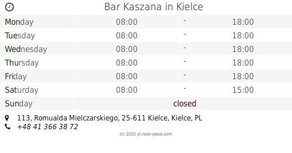
Bar Kaszana
Romualda Mielczarskiego 113, Kielce
Bar
read more
938 m
Pub Kruk
aleja Solidarności 7, Kielce
Bar
read more
📑
all categories
Accounting
Administrative area level 1
Administrative area level 2
Airport
Amusement park
Aquarium
Art gallery
Atm
Bakery
Bank
Bar
Beauty salon
Bicycle store
Book store
Bowling alley
Bus station
Cafe
Campground
Car dealer
Car rental
Car repair
Car wash
Casino
Cemetery
Church
City hall
Clothing store
Colloquial area
Convenience store
Courthouse
Dentist
Department store
Doctor
Electrician
Electronics store
Embassy
Finance
Fire station
Florist
Food
Funeral home
Furniture store
Gas station
General contractor
Grocery or supermarket
Gym
Hair care
Hardware store
Health
Hindu Temple
Home goods store
Hospital
Insurance agency
Intersection
Jewelry store
Laundry
Lawyer
Library
Light rail station
Liquor store
Local government office
Locality
Locksmith
Lodging
Meal delivery
Meal takeaway
Mosque
Movie rental
Movie theater
Moving company
Museum
Natural feature
Neighborhood
Night club
Painter
Park
Parking
Pet store
Pharmacy
Physiotherapist
Place of worship
Plumber
Point of interest
Police
Political
Post office
Premise
Real estate agency
Restaurant
Roofing contractor
Route
Rv park, camping
School
Shoe store
Shopping mall
Spa
Stadium
Storage
Store
Subpremise
Subway station
Supermarket
Synagogue
Taxi stand
Train station
Transit station
Travel agency
University
Veterinary care
Zoo
administrative area level 3
sublocality level 1
↑