Bar nearby Ogródek
Poland
Bar nearby Ogródek
Ogródek
Żeliwna 29, Katowice Polen
contacts phone
:
+48
Latitude:
50.2529824
, Longitude:
18.9913054
read more
nearest Bar
865 m
Pub Czarny Diament
Mikołowska 117, Katowice
Bar
read more
937 m
Alter Ego
Pola 35, Katowice
Bar
read more
1.461 km
Lody Włoskie
Pośpiecha 2, Katowice
Bar
read more
1.533 km
Garden Pub
Gliwicka 53, Katowice
Bar
read more
1.553 km
Pepita Tapas & Wine Bar
ul. Gliwicka 49, Katowice
Bar
read more
1.56 km
Atmosfera
Kilińskiego 20, Katowice
Bar
read more
1.619 km
Klub Inwersja
I piętro, Gliwicka 10, Katowice
Bar
read more
1.736 km
Czerwone Różowe Białe
Żwirki i Wigury 5, Katowice
Bar
read more
1.741 km
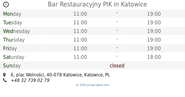
Bar Restauracyjny PIK
plac Wolności 6, Katowice
Bar
read more
1.773 km
Galeria Libero
Powstańców 3, Katowice
Bar
read more
1.775 km
Gwardia Katowice
Katowice
Bar
read more
1.785 km
Bar Harnaś
Kościuszki 29, Katowice
Bar
read more
1.791 km
Bar Piwny BLASZOK
Grabskiego 10, Katowice
Bar
read more
1.795 km
Istambul Kebab
3 Maja 33, Katowice
Bar
read more
1.851 km
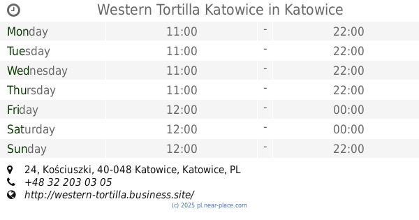
Western Tortilla Katowice
Kościuszki 24, Katowice
Bar
read more
1.928 km
Wściekły Pies
Słowackiego 16, Katowice
Bar
read more
1.96 km
Bar Diamant
3 Maja 23, Katowice
Bar
read more
1.968 km
Pub Katowice 5 peron 24h
Konopnickiej 3, Katowice
Bar
read more
1.972 km
Dixie Bar food & drinks
15 23, 3 Maja, Katowice
Bar
read more
1.972 km
Dixie Bar food&drinks
15 23, 3 Maja, Katowice
Bar
read more
2.011 km
Ogródek Adam
Szadoka 17, Katowice
Bar
read more
2.053 km
Pub Piano Bar Joker
Stawowa 13, Katowice
Bar
read more
2.083 km
Gorączka
Stawowa 5, Katowice
Bar
read more
2.091 km
Tawerna
Stawowa 3, Katowice
Bar
read more
2.155 km
Szama Zapiekanki z pieca & Frytki Belgijskie
Mickiewicza 20, Katowice
Bar
read more
📑
all categories
Accounting
Administrative area level 1
Administrative area level 2
Airport
Amusement park
Aquarium
Art gallery
Atm
Bakery
Bank
Bar
Beauty salon
Bicycle store
Book store
Bowling alley
Bus station
Cafe
Campground
Car dealer
Car rental
Car repair
Car wash
Casino
Cemetery
Church
City hall
Clothing store
Colloquial area
Convenience store
Courthouse
Dentist
Department store
Doctor
Electrician
Electronics store
Embassy
Finance
Fire station
Florist
Food
Funeral home
Furniture store
Gas station
General contractor
Grocery or supermarket
Gym
Hair care
Hardware store
Health
Hindu Temple
Home goods store
Hospital
Insurance agency
Intersection
Jewelry store
Laundry
Lawyer
Library
Light rail station
Liquor store
Local government office
Locality
Locksmith
Lodging
Meal delivery
Meal takeaway
Mosque
Movie rental
Movie theater
Moving company
Museum
Natural feature
Neighborhood
Night club
Painter
Park
Parking
Pet store
Pharmacy
Physiotherapist
Place of worship
Plumber
Point of interest
Police
Political
Post office
Premise
Real estate agency
Restaurant
Roofing contractor
Route
Rv park, camping
School
Shoe store
Shopping mall
Spa
Stadium
Storage
Store
Subpremise
Subway station
Supermarket
Synagogue
Taxi stand
Train station
Transit station
Travel agency
University
Veterinary care
Zoo
administrative area level 3
sublocality level 1
↑