Bar nearby Karczma Śląska
Poland
Bar nearby Karczma Śląska
Karczma Śląska
140, Radoszowska, 41-707, Ruda Śląska, Ruda Śląska, PL Polska
contacts phone
:
+48
Latitude:
50.2543315
, Longitude:
18.9070178
larger map & directions
read more
nearest Bar
657 m
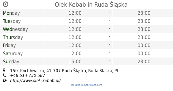
Olek Kebab
Kochłowicka 150, Ruda Śląska
Bar
read more
1.726 km
City Pub
Kopalniana 1, Ruda Śląska
Bar
read more
1.769 km
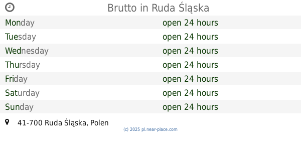
Brutto
Ruda Slaska
Bar
read more
1.982 km
Młody Gluś
11 Listopada 7, Ruda Śląska
Bar
read more
2.178 km
bistro przy kachloku
Ks. Potyki 24, Ruda Śląska
Bar
read more
2.178 km
bistro przy kachloku
24 Ks, Potyki, Ruda Śląska
Bar
read more
2.494 km
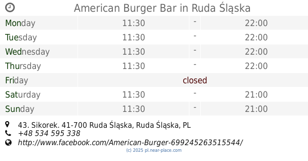
American Burger Bar
Sikorek 43, Ruda Śląska
Bar
read more
2.563 km
Bar Laguna
Karpacka 48, Chorzów
Bar
read more
2.575 km
Pub Malboro
Batorego 48, Chorzów
Bar
read more
2.58 km
Bar Piwny Piwniczka
Karpacka 39, Chorzów
Bar
read more
2.58 km
Bar Piwniczka
Karpacka 39, Chorzów
Bar
read more
2.833 km
Carlo
Skrajna, Chorzów
Bar
read more
2.845 km
Bar
Skrajna 20A, Chorzów
Bar
read more
3.003 km
Pub Dzies10na
Kochanowskiego 3, Chorzów
Bar
read more
3.026 km
Bar Santos
Chorzów
Bar
read more
3.039 km
4YOUKEBAB
Batorego 21, Chorzów
Bar
read more
3.119 km
Focus
16 Lipca 27, Chorzów
Bar
read more
3.272 km
Bar Pod Lustrami
16 Lipca 19, Chorzów
Bar
read more
3.274 km
To Tukej
Hutnicza 1, Chorzów
Bar
read more
3.423 km
BAR
Sienkiewicza 10A, Ruda Śląska
Bar
read more
3.514 km
Pod Łososiem
Teatralna 5c, Ruda Śląska
Bar
read more
3.741 km
Mr. Hamburger
1 Maja 310, Ruda Śląska
Bar
read more
3.841 km
Drink BAR BUFFO
Armii Krajowej 53, Chorzów
Bar
read more
3.873 km
Beer House Chorzów
Aleja Bojowników o Wolność i Demokrację 51, Chorzów
Bar
read more
3.983 km
Sayonara
Aleja Bojowników o Wolność i Demokrację 45, Chorzów
Bar
read more
📑
all categories
Accounting
Administrative area level 1
Administrative area level 2
Airport
Amusement park
Aquarium
Art gallery
Atm
Bakery
Bank
Bar
Beauty salon
Bicycle store
Book store
Bowling alley
Bus station
Cafe
Campground
Car dealer
Car rental
Car repair
Car wash
Casino
Cemetery
Church
City hall
Clothing store
Colloquial area
Convenience store
Courthouse
Dentist
Department store
Doctor
Electrician
Electronics store
Embassy
Finance
Fire station
Florist
Food
Funeral home
Furniture store
Gas station
General contractor
Grocery or supermarket
Gym
Hair care
Hardware store
Health
Hindu Temple
Home goods store
Hospital
Insurance agency
Intersection
Jewelry store
Laundry
Lawyer
Library
Light rail station
Liquor store
Local government office
Locality
Locksmith
Lodging
Meal delivery
Meal takeaway
Mosque
Movie rental
Movie theater
Moving company
Museum
Natural feature
Neighborhood
Night club
Painter
Park
Parking
Pet store
Pharmacy
Physiotherapist
Place of worship
Plumber
Point of interest
Police
Political
Post office
Premise
Real estate agency
Restaurant
Roofing contractor
Route
Rv park, camping
School
Shoe store
Shopping mall
Spa
Stadium
Storage
Store
Subpremise
Subway station
Supermarket
Synagogue
Taxi stand
Train station
Transit station
Travel agency
University
Veterinary care
Zoo
administrative area level 3
sublocality level 1
↑