Bar nearby Green Way
Poland
Bar nearby Green Way
Green Way
Zeylanda 6, Poznań Polska
contacts phone
:
+48
Latitude:
52.4071283
, Longitude:
16.9076968
read more
nearest Bar
280 m
MUS Bar & View
Roosevelta 22, Poznań
Bar
read more
356 m
Agawa. Pub
Mickiewicza 28, Poznań
Bar
read more
378 m
Bar u Jędrusia
Dworcowa, Poznań
Bar
read more
506 m
Wine & Friends
Szamarzewskiego 2, Poznań
Bar
read more
580 m
Nowy Franklin
Roosevelta 10, Poznań
Bar
read more
605 m
Czeski Pub Szwejk
Wieniawskiego 5/9, Poznań
Bar
read more
663 m
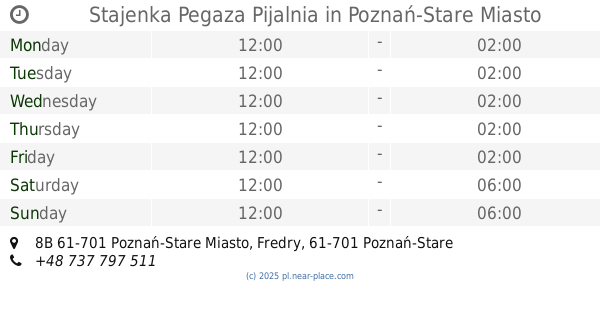
Stajenka Pegaza Pijalnia
Fredry 8B 61-701 Poznań-Stare Miasto, Poznań-Stare Miasto
Bar
read more
671 m
"OVER SEA" Kawa, Ciastka I Kanapki
Dworcowa 1, Poznań
Bar
read more
675 m
Bar Bartek
Towarowa 35, Poznań
Bar
read more
696 m
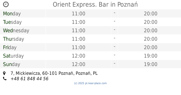
Orient Express. Bar
Mickiewicza 7, Poznań
Bar
read more
698 m
Thai WOK
Matyi 2, Poznań
Bar
read more
707 m
The Dubliner Irish Pub
Święty Marcin 80/82, Poznań
Bar
read more
709 m
Pitu Pitu
Wawrzyniaka 13, Poznań
Bar
read more
737 m
MAD MAX Reaktywacja Pub
Poznańska 8, Poznań
Bar
read more
745 m
STACJA URBANO
Wawrzyniaka 19, Poznań
Bar
read more
757 m
#StacjaUrbano
#StacjaUrbano #Wawrzyniala19, Poznań
Bar
read more
766 m
Fort Colomb
Poznań, ul. Powstańców Wlkp, Poznań
Bar
read more
766 m
SEVI ORIENTAL
Matyi 2, Poznań
Bar
read more
908 m
Konkret
Szamarzewskiego 37, Poznań
Bar
read more
913 m
Hotel NH Poznan
Święty Marcin 67, Poznań
Bar
read more
929 m
Wodopój
Gwarna 6, Poznań
Bar
read more
935 m
Pad Club
Gwarna 8, Poznań
Bar
read more
1.158 km
Gastro. Bar
Galla Anonima 11C, Poznań
Bar
read more
1.226 km
Whisky Bar 88
Stanisława Wyspiańskiego 26A, Poznań
Bar
read more
1.226 km
Whisky Bar 88
Wyspiańskiego 26A, Poznań
Bar
read more
📑
all categories
Accounting
Administrative area level 1
Administrative area level 2
Airport
Amusement park
Aquarium
Art gallery
Atm
Bakery
Bank
Bar
Beauty salon
Bicycle store
Book store
Bowling alley
Bus station
Cafe
Campground
Car dealer
Car rental
Car repair
Car wash
Casino
Cemetery
Church
City hall
Clothing store
Colloquial area
Convenience store
Courthouse
Dentist
Department store
Doctor
Electrician
Electronics store
Embassy
Finance
Fire station
Florist
Food
Funeral home
Furniture store
Gas station
General contractor
Grocery or supermarket
Gym
Hair care
Hardware store
Health
Hindu Temple
Home goods store
Hospital
Insurance agency
Intersection
Jewelry store
Laundry
Lawyer
Library
Light rail station
Liquor store
Local government office
Locality
Locksmith
Lodging
Meal delivery
Meal takeaway
Mosque
Movie rental
Movie theater
Moving company
Museum
Natural feature
Neighborhood
Night club
Painter
Park
Parking
Pet store
Pharmacy
Physiotherapist
Place of worship
Plumber
Point of interest
Police
Political
Post office
Premise
Real estate agency
Restaurant
Roofing contractor
Route
Rv park, camping
School
Shoe store
Shopping mall
Spa
Stadium
Storage
Store
Subpremise
Subway station
Supermarket
Synagogue
Taxi stand
Train station
Transit station
Travel agency
University
Veterinary care
Zoo
administrative area level 3
sublocality level 1
↑