Bar nearby Dram Whisky Explorers Bar
Poland
Bar nearby Dram Whisky Explorers Bar
Dram Whisky Explorers Bar
Stary Rynek 92, Poznań Polen
contacts phone
:
+48
Latitude:
52.4090292
, Longitude:
16.9338903
read more
nearest Bar
76 m
Tanner's Irish Pub
Wroniecka 21, Poznań
Bar
read more
96 m
Klubokawiarnia Meskalina
Stary Rynek 6, Poznań
Bar
read more
136 m
Ministerstwo Browaru
Wroniecka 16, Poznań
Bar
read more
144 m
New SHARK Club
Stary Rynek 48, Poznań
Bar
read more
177 m
Locus
Szewska 20 a, Poznań
Bar
read more
177 m
Locus
Szewska 20 a, 61-760, Poznań
Bar
read more
182 m
MIASTO
Szewska 20, Poznań
Bar
read more
183 m
Berbella
Wielka 23, Poznań
Bar
read more
189 m
The Brothers Pub
Szewska 19, Poznań
Bar
read more
208 m
Apetyt
Szkolna 4, Poznań
Bar
read more
223 m
Peryskop Ogród
Szewska 8, Poznań
Bar
read more
336 m
Bistro Tancereczka
61-836, Jaskółcza, Poznań
Bar
read more
344 m
KoKoKo The Chicken Bar
Szkolna 15, Poznań
Bar
read more
412 m
Winelove
Święty Wojciech 7/1, Poznań
Bar
read more
478 m
Pub „Elizjum”
Nowowiejskiego 10/1a, Poznań
Bar
read more
549 m
O Bulwa
Św. Marcin 17, Poznań
Bar
read more
555 m
Old School Pub Piwomania
plac Bernardyński 2, Poznań
Bar
read more
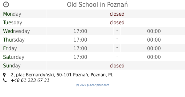
556 m
Old School
plac Bernardyński 2, Poznań
Bar
read more
678 m
Fajfa 32
Ratajczaka 32, Poznań
Bar
read more
714 m
Amore del Tropico
Ratajczaka 26, Poznań
Bar
read more
721 m
Fajfa 32
Ratajczaka 32/5, Poznań
Bar
read more
764 m
Łapu Papu Baguette
Kwiatowa 1, Poznań
Bar
read more
886 m
Weranda Take Away
Półwiejska 41, Poznań
Bar
read more
937 m
La Passion du Vin. Winiarnia
Półwiejska 42, Poznań
Bar
read more
1.054 km
Sport Club Poznań
plac Andersa 1, Poznań
Bar
read more
📑
all categories
Accounting
Administrative area level 1
Administrative area level 2
Airport
Amusement park
Aquarium
Art gallery
Atm
Bakery
Bank
Bar
Beauty salon
Bicycle store
Book store
Bowling alley
Bus station
Cafe
Campground
Car dealer
Car rental
Car repair
Car wash
Casino
Cemetery
Church
City hall
Clothing store
Colloquial area
Convenience store
Courthouse
Dentist
Department store
Doctor
Electrician
Electronics store
Embassy
Finance
Fire station
Florist
Food
Funeral home
Furniture store
Gas station
General contractor
Grocery or supermarket
Gym
Hair care
Hardware store
Health
Hindu Temple
Home goods store
Hospital
Insurance agency
Intersection
Jewelry store
Laundry
Lawyer
Library
Light rail station
Liquor store
Local government office
Locality
Locksmith
Lodging
Meal delivery
Meal takeaway
Mosque
Movie rental
Movie theater
Moving company
Museum
Natural feature
Neighborhood
Night club
Painter
Park
Parking
Pet store
Pharmacy
Physiotherapist
Place of worship
Plumber
Point of interest
Police
Political
Post office
Premise
Real estate agency
Restaurant
Roofing contractor
Route
Rv park, camping
School
Shoe store
Shopping mall
Spa
Stadium
Storage
Store
Subpremise
Subway station
Supermarket
Synagogue
Taxi stand
Train station
Transit station
Travel agency
University
Veterinary care
Zoo
administrative area level 3
sublocality level 1
↑