Bar nearby Blue Cafe
Coronavirus disease (COVID-19) Situation
confirmed cases
6661991
deaths
120598
Poland
Bar nearby Blue Cafe
Blue Cafe
83, osiedle Tysiąclecia, 30-001, Kraków, Kraków, PL Polska
contacts phone
:
+48
Latitude:
50.0942749
, Longitude:
19.9982781
larger map & directions
read more
nearest Bar
109 m
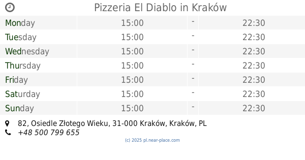
Pizzeria El Diablo
Osiedle Złotego Wieku 82, Kraków
Bar
read more
734 m
Przystanek Pierogarnia
16a, Kraków
Bar
read more
871 m
Prima Bar. Maniak M.
osiedle Józefa Strusia 20, Kraków
Bar
read more
1.689 km
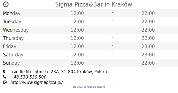
Sigma Pizza&Bar
osiedle Na Lotnisku 23A, Kraków
Bar
read more
1.699 km
A'la Basta!
Gen. Leopolda Okulickiego 51, Kraków
Bar
read more
1.848 km
Drink Bar
Osiedle Dywizjonu 303 58A, Kraków
Bar
read more
1.901 km
Bar Mleczny
Kraków
Bar
read more
1.907 km
Grill Box
Aleja Generała Tadeusza Bora-Komorowskiego 15B, Kraków
Bar
read more
2.002 km
KORPO
Aleja Generała Tadeusza Bora-Komorowskiego 9, Kraków
Bar
read more
2.041 km
Jadłodajnia Miła
Mirosława Dzielskiego 2, Kraków
Bar
read more
2.272 km
yetipizza
Mieczysława Pszona 4, Kraków
Bar
read more
2.448 km
Żarełko
Mieczysława Medweckiego 5, Kraków
Bar
read more
2.449 km
Bar Bomba
Kraków
Bar
read more
2.449 km
Luz-Blues Pub
Majora 5A, Kraków
Bar
read more
2.529 km
Kebab Sahara
Obrońców Krzyża 16, Kraków
Bar
read more
2.53 km
Bar Pod Brzózkami
Gustawa Pokrzywki 11, Kraków
Bar
read more
2.745 km
Zapiekanki Bieńczyckie
Bieńczycki Plac Targowy 28, Kraków
Bar
read more
2.8 km
Fuxon
Szybka 25, Kraków
Bar
read more
2.802 km
Poland Siesta - Lunch Bar
Kuźnicy Kołłątajowskiej 13, Kraków
Bar
read more
2.919 km
cateringroup
aleja Jana Pawła II 188, Kraków
Bar
read more
2.945 km
Bar Gastronomiczny ,,Majka"
os. Teatralne 11, Kraków
Bar
read more
3.005 km
Rabona - kawiarnia, pub, ogródek, konferencje
świętego Andrzeja Boboli 5, Kraków
Bar
read more
3.192 km
Jadłodajnia u Jana
Osiedle Kolorowe 10, Kraków
Bar
read more
3.372 km
Pub Aquarium
Biskupa Piotra Tomickiego 3, Kraków
Bar
read more
3.485 km
Bar Hamburger
osiedle Centrum C 11, Kraków
Bar
read more
📑
all categories
Accounting
Administrative area level 1
Administrative area level 2
Airport
Amusement park
Aquarium
Art gallery
Atm
Bakery
Bank
Bar
Beauty salon
Bicycle store
Book store
Bowling alley
Bus station
Cafe
Campground
Car dealer
Car rental
Car repair
Car wash
Casino
Cemetery
Church
City hall
Clothing store
Colloquial area
Convenience store
Courthouse
Dentist
Department store
Doctor
Electrician
Electronics store
Embassy
Finance
Fire station
Florist
Food
Funeral home
Furniture store
Gas station
General contractor
Grocery or supermarket
Gym
Hair care
Hardware store
Health
Hindu Temple
Home goods store
Hospital
Insurance agency
Intersection
Jewelry store
Laundry
Lawyer
Library
Light rail station
Liquor store
Local government office
Locality
Locksmith
Lodging
Meal delivery
Meal takeaway
Mosque
Movie rental
Movie theater
Moving company
Museum
Natural feature
Neighborhood
Night club
Painter
Park
Parking
Pet store
Pharmacy
Physiotherapist
Place of worship
Plumber
Point of interest
Police
Political
Post office
Premise
Real estate agency
Restaurant
Roofing contractor
Route
Rv park, camping
School
Shoe store
Shopping mall
Spa
Stadium
Storage
Store
Subpremise
Subway station
Supermarket
Synagogue
Taxi stand
Train station
Transit station
Travel agency
University
Veterinary care
Zoo
administrative area level 3
sublocality level 1
↑