Bar nearby Bar
Poland
Bar nearby Bar
Bar
19, Stańczyka, 26-600, Radom, Radom, PL Polska
contacts phone
:
+48
Latitude:
51.403563
, Longitude:
21.1492882
larger map & directions
read more
nearest Bar
134 m
Kuźnia. Bar
Jacka Malczewskiego 9/11, Radom
Bar
read more
177 m
Piwiarnia
Żeromskiego 15, Radom
Bar
read more
214 m
Before Shot Bar
Stefana Żeromskiego 19, Radom
Bar
read more
290 m
Piwiarnia
Radom
Bar
read more
317 m
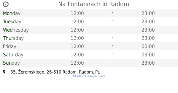
Na Fontannach
Żeromskiego 35, Radom
Bar
read more
331 m
Piąta Klepka
Żeromskiego 29, Radom
Bar
read more
355 m
Bar Sabat
plac Jagielloński 8, Radom
Bar
read more
364 m
Saymon Shot&bar
marsz. Ferdynanda Focha 5, Radom
Bar
read more
368 m
Sajmon. Bar
marsz. Ferdynanda Focha, Radom
Bar
read more
374 m
Bar Głodny Królik
Jacka Malczewskiego 21, Radom
Bar
read more
383 m
Ministerstwo Śledzia I Wódki
Żeromskiego 33, Radom
Bar
read more
418 m
Pod Fontannami
Żeromskiego 37, Radom
Bar
read more
429 m
Scandal SHOT BAR
plac Jagielloński 12, Radom
Bar
read more
512 m
Hostel & Retro Pub
Rynek 6, Radom
Bar
read more
611 m
Sushi Room
Andrzeja Struga 18, Radom
Bar
read more
624 m
Kebab Marhaba
Romualda Traugutta 44, Radom
Bar
read more
632 m
Kurcze Pieczone
Józefa Mireckiego 14, Radom
Bar
read more
688 m
Zapiecek
marsz. Józefa Piłsudskiego 2, Radom
Bar
read more
733 m
LUNCH FRESH
Mieczysława Niedziałkowskiego 16, Radom
Bar
read more
763 m
Cargo GastroPub
Marii Curie-Skłodowskiej 4, Radom
Bar
read more
827 m
pab 9 lotka
Henryka Sienkiewicza 4, Radom
Bar
read more
956 m
,,Bar Pietrek"
Tadeusza Kościuszki 5A, Radom
Bar
read more
982 m
BAR KUBUŚ
Tadeusza Kościuszki 8A, Radom
Bar
read more
1.002 km
Pub Katakumby
plac Stare Miasto 11, Radom
Bar
read more
1.115 km
Enoteka Verona
25 Czerwca 36, Radom
Bar
read more
📑
all categories
Accounting
Administrative area level 1
Administrative area level 2
Airport
Amusement park
Aquarium
Art gallery
Atm
Bakery
Bank
Bar
Beauty salon
Bicycle store
Book store
Bowling alley
Bus station
Cafe
Campground
Car dealer
Car rental
Car repair
Car wash
Casino
Cemetery
Church
City hall
Clothing store
Colloquial area
Convenience store
Courthouse
Dentist
Department store
Doctor
Electrician
Electronics store
Embassy
Finance
Fire station
Florist
Food
Funeral home
Furniture store
Gas station
General contractor
Grocery or supermarket
Gym
Hair care
Hardware store
Health
Hindu Temple
Home goods store
Hospital
Insurance agency
Intersection
Jewelry store
Laundry
Lawyer
Library
Light rail station
Liquor store
Local government office
Locality
Locksmith
Lodging
Meal delivery
Meal takeaway
Mosque
Movie rental
Movie theater
Moving company
Museum
Natural feature
Neighborhood
Night club
Painter
Park
Parking
Pet store
Pharmacy
Physiotherapist
Place of worship
Plumber
Point of interest
Police
Political
Post office
Premise
Real estate agency
Restaurant
Roofing contractor
Route
Rv park, camping
School
Shoe store
Shopping mall
Spa
Stadium
Storage
Store
Subpremise
Subway station
Supermarket
Synagogue
Taxi stand
Train station
Transit station
Travel agency
University
Veterinary care
Zoo
administrative area level 3
sublocality level 1
↑