Bar nearby Bar Fiołek
Poland
Bar nearby Bar Fiołek
Bar Fiołek
40-001 Chorzów, Polska
contacts phone
:
+48
Latitude:
50.2854231
, Longitude:
18.9809763
larger map & directions
read more
nearest Bar
20 m
Bar Promenada
Chorzów
Bar
read more
111 m
Kontenery Kultury
Chorzów
Bar
read more
416 m
Róża
aleja Różana 1, Chorzów
Bar
read more
740 m
Kurczak z rożna-kebab
872, Zawiszy Czarnego 7, Katowice
Bar
read more
836 m
Bar Oaza
aleja Żyrafy 3, Chorzów
Bar
read more
837 m
Szarotka. Bar
aleja Żyrafy 5, Chorzów
Bar
read more
919 m
Bar Żyrafa
Chorzów
Bar
read more
1.121 km
Rock&Rollka - nie tylko SUSHI BAR
Zielony Zaułek 1/1, Chorzów
Bar
read more
1.129 km
Bar Kormoran
Chorzow
Bar
read more
1.131 km
New York Hot Dog
CH Aks, Parkowa 20, Chorzów
Bar
read more
1.815 km
Bar pod kasztanem
Dębowa 32, Katowice
Bar
read more
1.991 km
Szynk PRL
Księcia Józefa Poniatowskiego 13, Chorzów
Bar
read more
2.074 km
London Pub
Ulica Katowicka 58, Chorzów
Bar
read more
2.075 km
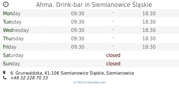
Ahma. Drink-bar
Grunwaldzka 6, Siemianowice Śląskie
Bar
read more
2.084 km
Bar Aleksandra
Racławicka 32, Chorzów
Bar
read more
2.117 km
Pub Beer Jugol
Ściegiennego 94, Katowice
Bar
read more
2.189 km
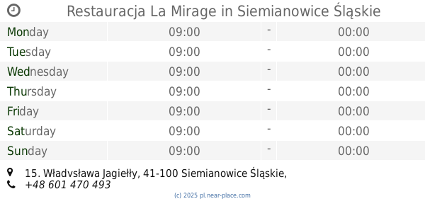
Restauracja La Mirage
Władysława Jagiełły 15, Siemianowice Śląskie
Bar
read more
2.202 km
Doner Imbiss Kebab
Górnośląska 2, Chorzów
Bar
read more
2.214 km
Minibrowar Reden
Jana III Sobieskiego 17, Chorzów
Bar
read more
2.272 km
Fish & Chips Eat In Or Take It Away
Armii Krajowej 117, Chorzów
Bar
read more
2.294 km
Zbyszko
Jagiełły 27, Władysława Jagiełły 27, Siemianowice Śląskie
Bar
read more
2.314 km
Krokiecik
Wróblewskiego 25, Siemianowice Śląskie
Bar
read more
2.327 km
Kraken Pub
Rynek 13/U3, Chorzów
Bar
read more
2.328 km
RED & BLACK
Rynek 13/4 , 41-500, Chorzów
Bar
read more
2.372 km
Warka. Piwiarnia Chorzów
Powstańców 1/1, Chorzów
Bar
read more
📑
all categories
Accounting
Administrative area level 1
Administrative area level 2
Airport
Amusement park
Aquarium
Art gallery
Atm
Bakery
Bank
Bar
Beauty salon
Bicycle store
Book store
Bowling alley
Bus station
Cafe
Campground
Car dealer
Car rental
Car repair
Car wash
Casino
Cemetery
Church
City hall
Clothing store
Colloquial area
Convenience store
Courthouse
Dentist
Department store
Doctor
Electrician
Electronics store
Embassy
Finance
Fire station
Florist
Food
Funeral home
Furniture store
Gas station
General contractor
Grocery or supermarket
Gym
Hair care
Hardware store
Health
Hindu Temple
Home goods store
Hospital
Insurance agency
Intersection
Jewelry store
Laundry
Lawyer
Library
Light rail station
Liquor store
Local government office
Locality
Locksmith
Lodging
Meal delivery
Meal takeaway
Mosque
Movie rental
Movie theater
Moving company
Museum
Natural feature
Neighborhood
Night club
Painter
Park
Parking
Pet store
Pharmacy
Physiotherapist
Place of worship
Plumber
Point of interest
Police
Political
Post office
Premise
Real estate agency
Restaurant
Roofing contractor
Route
Rv park, camping
School
Shoe store
Shopping mall
Spa
Stadium
Storage
Store
Subpremise
Subway station
Supermarket
Synagogue
Taxi stand
Train station
Transit station
Travel agency
University
Veterinary care
Zoo
administrative area level 3
sublocality level 1
↑