Atm nearby Euronet
Poland
Atm nearby Euronet
Euronet
ul. Stanisława Matyi 2, Avenida Poznań, Poznań Polska
contacts phone
:
+48
Latitude:
52.402773
, Longitude:
16.913528
read more
nearest Atm
8 m
Bankomat - Pekao
Dworcowa 1, Poznań
Atm
read more
165 m
Planet Cash. Wpłatomat
Matyi 2, Poznań
Atm
read more
190 m
Bank Zachodni WBK
Dworcowa 1, Poznań
Atm
read more
223 m
PKO Bankomat
Łazarz, Poznań
Atm
read more
584 m
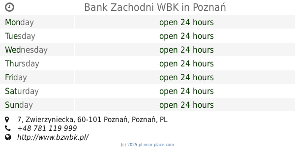
Bank Zachodni WBK
Zwierzyniecka 7, Poznań
Atm
read more
648 m
Commercial Union. Bankomat
Zeylanda 3, Poznań
Atm
read more
676 m
PKO BP
Święty Marcin 78, Poznań
Atm
read more
695 m
Bank Spółdzielczy
Zwierzyniecka 14/16, Poznań
Atm
read more
719 m
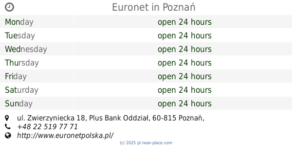
Euronet
ul. Zwierzyniecka 18, Plus Bank Oddział, Poznań
Atm
read more
763 m
Bank Zachodni WBK
Święty Marcin 66/72, Poznań
Atm
read more
801 m
Bankomat Banku Pekao S.A.
ul. Święty Marcin 52/56, siedziba Oddziału, Poznań
Atm
read more
814 m
DB
Półwiejska 42, Poznań
Atm
read more
854 m
Planet Cash. Wpłatomat
27 Grudnia 13, Poznań
Atm
read more
890 m
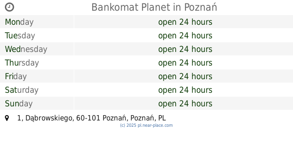
Bankomat Planet
Dąbrowskiego 1, Poznań
Atm
read more
903 m
Bankomat - Alior Bank
Dąbrowskiego 10, Poznań
Atm
read more
911 m
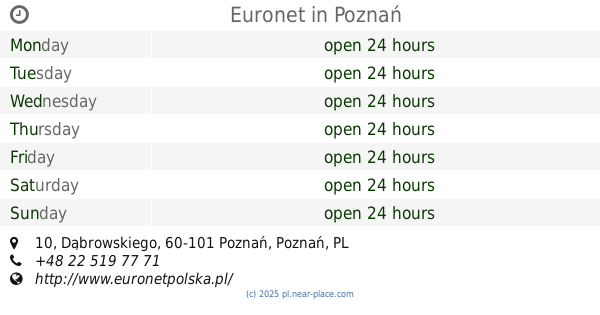
Euronet
Dąbrowskiego 10, Poznań
Atm
read more
916 m
Bank BPH - Bankomat partnerski
Ratajczaka 31, Poznań
Atm
read more
941 m
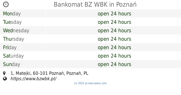
Bankomat BZ WBK
Matejki 1, Poznań
Atm
read more
945 m
Nordea Bank Polska S.A. Bankomat. Wpłatomat
Głogowska 55, Poznań
Atm
read more
1.013 km
Euronet
ul. Półwiejska 47, Biurowiec, Poznań
Atm
read more
1.036 km
ATM - Euronet
Święty Marcin 24, Poznań
Atm
read more
1.067 km
ATM - Euronet
ul. Matejki 48-49, Alior Bank, oddział, Poznań
Atm
read more
1.092 km
Bank Gospodarki Żywnościowej SA
Libelta 6, Poznań
Atm
read more
1.107 km
Euronet
ul. Głogowska 67, Credit Agricole Bank Polska S.A., Poznań
Atm
read more
1.376 km
Euronet
Młyńska 14, Poznań
Atm
read more
📑
all categories
Accounting
Administrative area level 1
Administrative area level 2
Airport
Amusement park
Aquarium
Art gallery
Atm
Bakery
Bank
Bar
Beauty salon
Bicycle store
Book store
Bowling alley
Bus station
Cafe
Campground
Car dealer
Car rental
Car repair
Car wash
Casino
Cemetery
Church
City hall
Clothing store
Colloquial area
Convenience store
Courthouse
Dentist
Department store
Doctor
Electrician
Electronics store
Embassy
Finance
Fire station
Florist
Food
Funeral home
Furniture store
Gas station
General contractor
Grocery or supermarket
Gym
Hair care
Hardware store
Health
Hindu Temple
Home goods store
Hospital
Insurance agency
Intersection
Jewelry store
Laundry
Lawyer
Library
Light rail station
Liquor store
Local government office
Locality
Locksmith
Lodging
Meal delivery
Meal takeaway
Mosque
Movie rental
Movie theater
Moving company
Museum
Natural feature
Neighborhood
Night club
Painter
Park
Parking
Pet store
Pharmacy
Physiotherapist
Place of worship
Plumber
Point of interest
Police
Political
Post office
Premise
Real estate agency
Restaurant
Roofing contractor
Route
Rv park, camping
School
Shoe store
Shopping mall
Spa
Stadium
Storage
Store
Subpremise
Subway station
Supermarket
Synagogue
Taxi stand
Train station
Transit station
Travel agency
University
Veterinary care
Zoo
administrative area level 3
sublocality level 1
↑