Pharmacy nearby Synergis
Poland
Pharmacy nearby Synergis
Synergis
7, Międzychodzka, 60-101, Poznań, Poznań, PL Polska
contacts phone
:
+48 61 662 43 14
Latitude:
52.4065085
, Longitude:
16.8773816
larger map & directions
read more
nearest Pharmacy
154 m
Apteka Wielkopolska
Grochowska 116, Poznań
Pharmacy
read more
237 m
Pharmacy Drug House
Grochowska 83-85, Poznań
Pharmacy
read more
237 m
Apteka Dom Leków
Grochowska 83-85, Poznań
Pharmacy
read more
357 m
Nova. Apteka
Ostroroga 36, Poznań
Pharmacy
read more
460 m
Apteka Całodobowa Dr.Max
Marcelińska 80, Poznań
Pharmacy
read more
465 m
Apteka Medkon
Jutrzenka 8/H1, Poznań
Pharmacy
read more
465 m
Medkon
Jutrzenka 8/H1, Poznań
Pharmacy
read more
473 m
Pod Wagą. Apteka
Ognik 18, Poznań
Pharmacy
read more
493 m
Apteka Słoneczna II
Swoboda 22, Poznań
Pharmacy
read more
534 m
Adamus. Apteka
Bukowska 100, Poznań
Pharmacy
read more
544 m
Apteka Rycerska
Rycerska 35, Poznań
Pharmacy
read more
719 m
Apteka Miodowa
Miodowa 4, Poznań
Pharmacy
read more
745 m
Apteka Fundacji Uniwersytetu Medycznego
Przybyszewskiego 49, Poznań
Pharmacy
read more
757 m
NASZA APTEKA
Przybyszewskiego 49, Poznań
Pharmacy
read more
844 m
Sagittarius. Apteka
Cześnikowska 2, Poznań
Pharmacy
read more
860 m
Apteka Słoneczna
Orężna 13, Poznań
Pharmacy
read more
863 m
Lawenda
Szamarzewskiego 82/84, Poznań
Pharmacy
read more
880 m
Apteka Wielkopolska
23, Marcelińska, Poznań
Pharmacy
read more
933 m
Apteka Wielkopolskiego Centrum Chorób Płuc i Gruźlicy SPZOZ
Szamarzewskiego 62, Poznań
Pharmacy
read more
933 m
Puls sp.j. Apteka. Seńczuk
Szamarzewskiego 62, Poznań
Pharmacy
read more
1.077 km
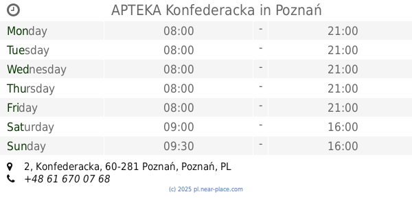
APTEKA Konfederacka
Konfederacka 2, Poznań
Pharmacy
read more
1.103 km
Apteka Cosmedica
198, Bukowska 156/lok B604 ,60, Poznań
Pharmacy
read more
1.629 km
Apteka Promienna
Palacza 96, Poznań
Pharmacy
read more
1.767 km
Szarotka sp.j. Apteka
Dąbrowskiego 66, Poznań
Pharmacy
read more
1.985 km
Pod Słońcem. Apteka
Keplera 1, Poznań
Pharmacy
read more
📑
all categories
Accounting
Administrative area level 1
Administrative area level 2
Airport
Amusement park
Aquarium
Art gallery
Atm
Bakery
Bank
Bar
Beauty salon
Bicycle store
Book store
Bowling alley
Bus station
Cafe
Campground
Car dealer
Car rental
Car repair
Car wash
Casino
Cemetery
Church
City hall
Clothing store
Colloquial area
Convenience store
Courthouse
Dentist
Department store
Doctor
Electrician
Electronics store
Embassy
Finance
Fire station
Florist
Food
Funeral home
Furniture store
Gas station
General contractor
Grocery or supermarket
Gym
Hair care
Hardware store
Health
Hindu Temple
Home goods store
Hospital
Insurance agency
Intersection
Jewelry store
Laundry
Lawyer
Library
Light rail station
Liquor store
Local government office
Locality
Locksmith
Lodging
Meal delivery
Meal takeaway
Mosque
Movie rental
Movie theater
Moving company
Museum
Natural feature
Neighborhood
Night club
Painter
Park
Parking
Pet store
Pharmacy
Physiotherapist
Place of worship
Plumber
Point of interest
Police
Political
Post office
Premise
Real estate agency
Restaurant
Roofing contractor
Route
Rv park, camping
School
Shoe store
Shopping mall
Spa
Stadium
Storage
Store
Subpremise
Subway station
Supermarket
Synagogue
Taxi stand
Train station
Transit station
Travel agency
University
Veterinary care
Zoo
administrative area level 3
sublocality level 1
↑