Park nearby Staw Pzw Nr 817
Coronavirus disease (COVID-19) Situation
confirmed cases
6661991
deaths
120598
Poland
Park nearby Staw Pzw Nr 817
Staw Pzw Nr 817
29B, Chorzowska, 41-900, Bytom, Bytom, PL Polska
contacts phone
:
+48
Latitude:
50.3365381
, Longitude:
18.9407522
larger map & directions
read more
nearest Park
451 m
Park im. A. Mickiewicza
Chorzowska 28H, Bytom
Park
read more
670 m
Miejsce odpoczynku
Cicha 10b, Bytom
Park
read more
807 m
ROD Ziemia Ojczysta
Sienna, Bytom
Park
read more
876 m
Ogródki Działkowe Przyjaźń I
Siemianowicka 107, Bytom
Park
read more
1.105 km
Szynol
Bytom
Park
read more
1.34 km
Ogródki Działkowe
Brzezińska 56, Piekary Śląskie
Park
read more
1.394 km
Zespół przyrodniczo-krajobrazowy Żabie Doły
Rynek 4, Chorzów
Park
read more
1.617 km
Park AMENDY
Unnamed Road, Bytom
Park
read more
1.7 km
Skwer Plac Grunwaldzki
Bytom
Park
read more
1.707 km
Skwer Sikorskiego
Bytom
Park
read more
1.726 km
ROD Zygmunt
41-909 ul, Fabryczna, Bytom
Park
read more
1.797 km
Miner Valley - Fishing pond
Główna 109, Chorzów
Park
read more
1.818 km
Plac Andrzeja Hiolskiego
Bytom
Park
read more
1.874 km
Ogródki Działkowe
Bytom
Park
read more
2.018 km
Park, fontanna z rzeźbami Tadeusza Sadowskiego
plac Akademicki, Bytom
Park
read more
2.018 km
Pomnik Towarzystwa Strzeleckiego Bractwa Kurkowego w Bytomiu
Bytom
Park
read more
2.174 km
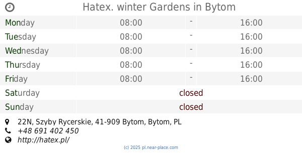
Hatex. winter Gardens
Szyby Rycerskie 22N, Bytom
Park
read more
2.188 km
Park Łagiewnicki
Bytom
Park
read more
2.408 km
Skwer Podkomisarza Tadeusza Bartosika
Księdza Franciszka Nawrota 24A, Bytom
Park
read more
2.452 km
Plac Targalskiego
Bytom
Park
read more
2.464 km
Aleja Marka Sienickiego
Unnamed Road, 41-902
Park
read more
2.517 km
Rodzinny Ogród Działkowy Sielanka
Ułańska 2, Bytom
Park
read more
2.632 km
Skwer im Św Matki Teresy z Kalkuty
Bytom ul, Strzelców Bytomskich 16, Bytom
Park
read more
3.084 km
Park Miejski Kachla
Wrocławska 41-902, Bytom
Park
read more
3.271 km
Rzeźby Czapli
Bytom
Park
read more
📑
all categories
Accounting
Administrative area level 1
Administrative area level 2
Airport
Amusement park
Aquarium
Art gallery
Atm
Bakery
Bank
Bar
Beauty salon
Bicycle store
Book store
Bowling alley
Bus station
Cafe
Campground
Car dealer
Car rental
Car repair
Car wash
Casino
Cemetery
Church
City hall
Clothing store
Colloquial area
Convenience store
Courthouse
Dentist
Department store
Doctor
Electrician
Electronics store
Embassy
Finance
Fire station
Florist
Food
Funeral home
Furniture store
Gas station
General contractor
Grocery or supermarket
Gym
Hair care
Hardware store
Health
Hindu Temple
Home goods store
Hospital
Insurance agency
Intersection
Jewelry store
Laundry
Lawyer
Library
Light rail station
Liquor store
Local government office
Locality
Locksmith
Lodging
Meal delivery
Meal takeaway
Mosque
Movie rental
Movie theater
Moving company
Museum
Natural feature
Neighborhood
Night club
Painter
Park
Parking
Pet store
Pharmacy
Physiotherapist
Place of worship
Plumber
Point of interest
Police
Political
Post office
Premise
Real estate agency
Restaurant
Roofing contractor
Route
Rv park, camping
School
Shoe store
Shopping mall
Spa
Stadium
Storage
Store
Subpremise
Subway station
Supermarket
Synagogue
Taxi stand
Train station
Transit station
Travel agency
University
Veterinary care
Zoo
administrative area level 3
sublocality level 1
↑