Night club nearby Plan B - night club
Coronavirus disease (COVID-19) Situation
confirmed cases
6661991
deaths
120598
Poland
Night club nearby Plan B - night club
Plan B - night club
plac Zbawiciela, Warszawa Polska
contacts phone
:
+48
Latitude:
52.2199587
, Longitude:
21.0184979
read more
nearest Night club
301 m
Infinity Pub
Lecha Kaczyńskiego 13, Warszawa
Night club
read more
348 m
Night Club Sofia
Polna 13, Warszawa
Night club
read more
377 m
Klub Riviera Remont
Waryńskiego 12a, Warszawa
Night club
read more
577 m
Lodi Dodi
Wilcza 23, 00, 544Warszawa
Night club
read more
592 m
12on14 Jazz Club
Stanisława Noakowskiego 16, Warszawa
Night club
read more
637 m
Apsters Club & Lounge
4/1, Marszałkowska, Warszawa
Night club
read more
640 m
Grizzly Gin Bar
46, Wilcza, Warszawa
Night club
read more
693 m
TORO PUB
Marszałkowska 72, Warszawa
Night club
read more
698 m
Toro
Marszałkowska 72, Warszawa
Night club
read more
719 m
Woda Ognista
Wilcza 8, Warszawa
Night club
read more
754 m
Black Diamond Club Warsaw
Hoża 35, Warszawa
Night club
read more
771 m
Klub na Hożej Domu Kultury Śródmieście
Hoża 41, Warszawa
Night club
read more
832 m
Winestone
Krucza 28, Warszawa
Night club
read more
974 m
Glam Club
Żurawia 22, Warszawa
Night club
read more
975 m
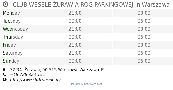
CLUB WESELE ŻURAWIA RÓG PARKINGOWEJ
Żurawia 32/34, Warszawa
Night club
read more
978 m
Klub 55
Plac Defilad 1, Warszawa
Night club
read more
982 m
Klub Park
aleja Niepodległości 196, Warszawa
Night club
read more
1.025 km
Meta Disco
Parkingowa 5, Warszawa
Night club
read more
1.05 km
Exotic Club
Nowogrodzka 31, Warszawa
Night club
read more
1.052 km
Bal Klub
Nowogrodzka 31, Warszawa
Night club
read more
1.064 km
XOXO Party
Marii Konopnickiej 6, Warszawa
Night club
read more
1.088 km
Stodola
Batorego 10, Warszawa
Night club
read more
1.118 km
Fista Club
Wspólna 70, Warszawa
Night club
read more
1.191 km
XXone Night Club
Aleje Jerozolimskie 53, Warszawa
Night club
read more
1.257 km
Pub Bolek
aleja Niepodległości 211, Warszawa
Night club
read more
📑
all categories
Accounting
Administrative area level 1
Administrative area level 2
Airport
Amusement park
Aquarium
Art gallery
Atm
Bakery
Bank
Bar
Beauty salon
Bicycle store
Book store
Bowling alley
Bus station
Cafe
Campground
Car dealer
Car rental
Car repair
Car wash
Casino
Cemetery
Church
City hall
Clothing store
Colloquial area
Convenience store
Courthouse
Dentist
Department store
Doctor
Electrician
Electronics store
Embassy
Finance
Fire station
Florist
Food
Funeral home
Furniture store
Gas station
General contractor
Grocery or supermarket
Gym
Hair care
Hardware store
Health
Hindu Temple
Home goods store
Hospital
Insurance agency
Intersection
Jewelry store
Laundry
Lawyer
Library
Light rail station
Liquor store
Local government office
Locality
Locksmith
Lodging
Meal delivery
Meal takeaway
Mosque
Movie rental
Movie theater
Moving company
Museum
Natural feature
Neighborhood
Night club
Painter
Park
Parking
Pet store
Pharmacy
Physiotherapist
Place of worship
Plumber
Point of interest
Police
Political
Post office
Premise
Real estate agency
Restaurant
Roofing contractor
Route
Rv park, camping
School
Shoe store
Shopping mall
Spa
Stadium
Storage
Store
Subpremise
Subway station
Supermarket
Synagogue
Taxi stand
Train station
Transit station
Travel agency
University
Veterinary care
Zoo
administrative area level 3
sublocality level 1
↑