Bar nearby Rock Friends
Coronavirus disease (COVID-19) Situation
confirmed cases
6661991
deaths
120598
Poland
Bar nearby Rock Friends
Rock Friends
Śliska 3, Warszawa Polska
contacts phone
:
+48
Latitude:
52.2323715
, Longitude:
21.001879
read more
nearest Bar
334 m
Bar Studio
plac Defilad 1, Warszawa
Bar
read more
363 m
Garda
Chmielna 98, Warszawa
Bar
read more
451 m
u Gaz
Chmielna 106, Warszawa
Bar
read more
538 m
Champions Sport Bar & Restaurant
Aleje Jerozolimskie 65/79, Warszawa
Bar
read more
558 m
Bar Cafe Thien Phu
Pańska 67, Warszawa
Bar
read more
560 m
Lobby Bar
Al. Jerozolimskie 65/79, Warsaw
Bar
read more
683 m
Lemoniada
Zgoda 9, Warszawa
Bar
read more
790 m
Chmiel
Chmielna 27/31 lok. 77, Warszawa
Bar
read more
872 m
Pub Contact
Aleje Jerozolimskie 33, Warszawa
Bar
read more
905 m
Pijalnia Wodki i Piwa
Nowogrodzka 27, Warszawa
Bar
read more
920 m
PiwPaw
Mazowiecka 9, Warszawa
Bar
read more
938 m
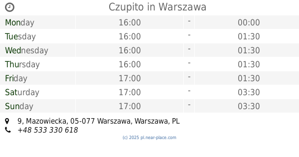
Czupito
Mazowiecka 9, Warszawa
Bar
read more
967 m
RITUAL Cocktail Club
Mazowiecka 12, Warszawa
Bar
read more
997 m
Mango Vegan
Bracka 20, Warszawa
Bar
read more
1000 m
LA VINOTHEQUE - Wine Bar
Grzybowska 63, Warszawa
Bar
read more
1.073 km
AFERA na Poznańskiej
Poznańska 13, Warszawa
Bar
read more
1.109 km
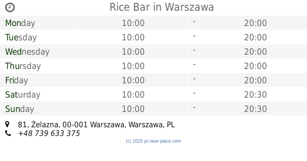
Rice Bar
81, Żelazna, Warszawa
Bar
read more
1.109 km
Rice Bar
Żelazna 81, Warszawa
Bar
read more
1.113 km
Alibaba Kebab
Marszałkowska 83, Warszawa
Bar
read more
1.133 km
GEMBA
Wilcza 50, Warszawa
Bar
read more
1.159 km
8 Dzień Tygodnia
Poznańska 7, Warszawa
Bar
read more
1.179 km
Autobar
Towarowa 1, Warszawa
Bar
read more
1.183 km
Parana
Marszałkowska 68/70 00-545, Warszawa
Bar
read more
1.203 km
Piwiarnia Warka
Wilcza 35/41, Warszawa
Bar
read more
1.283 km
Radisson Blu Sobieski
plac Zawiszy 1, Warszawa
Bar
read more
📑
all categories
Accounting
Administrative area level 1
Administrative area level 2
Airport
Amusement park
Aquarium
Art gallery
Atm
Bakery
Bank
Bar
Beauty salon
Bicycle store
Book store
Bowling alley
Bus station
Cafe
Campground
Car dealer
Car rental
Car repair
Car wash
Casino
Cemetery
Church
City hall
Clothing store
Colloquial area
Convenience store
Courthouse
Dentist
Department store
Doctor
Electrician
Electronics store
Embassy
Finance
Fire station
Florist
Food
Funeral home
Furniture store
Gas station
General contractor
Grocery or supermarket
Gym
Hair care
Hardware store
Health
Hindu Temple
Home goods store
Hospital
Insurance agency
Intersection
Jewelry store
Laundry
Lawyer
Library
Light rail station
Liquor store
Local government office
Locality
Locksmith
Lodging
Meal delivery
Meal takeaway
Mosque
Movie rental
Movie theater
Moving company
Museum
Natural feature
Neighborhood
Night club
Painter
Park
Parking
Pet store
Pharmacy
Physiotherapist
Place of worship
Plumber
Point of interest
Police
Political
Post office
Premise
Real estate agency
Restaurant
Roofing contractor
Route
Rv park, camping
School
Shoe store
Shopping mall
Spa
Stadium
Storage
Store
Subpremise
Subway station
Supermarket
Synagogue
Taxi stand
Train station
Transit station
Travel agency
University
Veterinary care
Zoo
administrative area level 3
sublocality level 1
↑