Bar nearby Gospoda Pod Żaglem
Coronavirus disease (COVID-19) Situation
confirmed cases
6661991
deaths
120598
Poland
Bar nearby Gospoda Pod Żaglem
Gospoda Pod Żaglem
Rudziniec Polen
contacts phone
:
+48
Latitude:
50.3965887
, Longitude:
18.4880138
read more
nearest Bar
5.189 km
Tawerna Kormorany
Nad Kanałem 1, Pyskowice
Bar
read more
5.423 km
Goldbar
Wiejska 60-61, Paczyna
Bar
read more
7.834 km
Bar Karlik
plac Miarki 2, Pyskowice
Bar
read more
9.17 km
Kufelek
gen. Sikorskiego 84, Pyskowice
Bar
read more
9.582 km
Warka. Piwiarnia
Armii Krajowej 24, Pyskowice
Bar
read more
9.749 km
Karlik
plac Miarki 2, Pyskowice
Bar
read more
9.86 km
Big Blue
Rynek 24, Gliwice
Bar
read more
13.108 km
Polishfood
Ossolińskich 40, Gliwice
Bar
read more
13.504 km
Bar portowy
Portowa 28, Gliwice
Bar
read more
16.524 km
The-Bartenders
Ignacego Domeyki 32, Gliwice
Bar
read more
16.847 km
Trio Catering & Bar
Zygmunta Starego 20, Gliwice
Bar
read more
16.863 km
Dobry Zbeer
Górnych Wałów 30, Gliwice
Bar
read more
16.876 km
Takk Bar & Lounge
Plebańska 14, Gliwice
Bar
read more
16.894 km
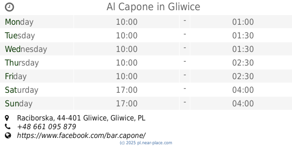
Al Capone
Raciborska, Gliwice
Bar
read more
16.908 km
Stary Kufel
Średnia 1, Gliwice
Bar
read more
17.026 km
Na Masę
Aleksandra Fredry 1, Gliwice
Bar
read more
17.128 km
Stary Piast
aleja Przyjaźni 35, Gliwice
Bar
read more
17.198 km
Pod Pierożkiem. Bar
Okopowa 8, Gliwice
Bar
read more
17.409 km
Concept Pub
aleja Przyjaźni, Gliwice
Bar
read more
17.665 km
JAGŁA
Łużycka 10, Gliwice
Bar
read more
17.712 km
Dream Bar
Stanisława Konarskiego 23, Gliwice
Bar
read more
17.772 km
Podwórko
16, Łużycka, Gliwice
Bar
read more
17.879 km
Stolowka & Restauracja "zaJadalnia"
Łużycka 24, Gliwice
Bar
read more
18.124 km
HELLGATE
Pszczyńska 80, Gliwice
Bar
read more
18.317 km
Jadlodajnia Lotos
Chorzowska, Gliwice
Bar
read more
📑
all categories
Accounting
Administrative area level 1
Administrative area level 2
Airport
Amusement park
Aquarium
Art gallery
Atm
Bakery
Bank
Bar
Beauty salon
Bicycle store
Book store
Bowling alley
Bus station
Cafe
Campground
Car dealer
Car rental
Car repair
Car wash
Casino
Cemetery
Church
City hall
Clothing store
Colloquial area
Convenience store
Courthouse
Dentist
Department store
Doctor
Electrician
Electronics store
Embassy
Finance
Fire station
Florist
Food
Funeral home
Furniture store
Gas station
General contractor
Grocery or supermarket
Gym
Hair care
Hardware store
Health
Hindu Temple
Home goods store
Hospital
Insurance agency
Intersection
Jewelry store
Laundry
Lawyer
Library
Light rail station
Liquor store
Local government office
Locality
Locksmith
Lodging
Meal delivery
Meal takeaway
Mosque
Movie rental
Movie theater
Moving company
Museum
Natural feature
Neighborhood
Night club
Painter
Park
Parking
Pet store
Pharmacy
Physiotherapist
Place of worship
Plumber
Point of interest
Police
Political
Post office
Premise
Real estate agency
Restaurant
Roofing contractor
Route
Rv park, camping
School
Shoe store
Shopping mall
Spa
Stadium
Storage
Store
Subpremise
Subway station
Supermarket
Synagogue
Taxi stand
Train station
Transit station
Travel agency
University
Veterinary care
Zoo
administrative area level 3
sublocality level 1
↑