Bar nearby Alania Kebab
Coronavirus disease (COVID-19) Situation
confirmed cases
6661991
deaths
120598
Poland
Bar nearby Alania Kebab
Alania Kebab
60, Obozowa, 01-161, Warszawa, Warszawa, PL Polen
contacts phone
:
+48
Latitude:
52.2475207
, Longitude:
20.9543942
larger map & directions
read more
nearest Bar
93 m
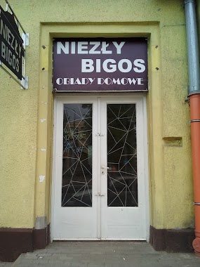
Niezły Bigos Bar Mleczny
Obozowa 61, Warszawa
Bar
read more
504 m
MPO
Obozowa 43, Warszawa
Bar
read more
589 m
Cafe Mirra
Deotymy 41, Warszawa
Bar
read more
801 m
Obiady Domowe
Ostroroga 29, Warszawa
Bar
read more
821 m
Chiński bar
Newelska 37, Warszawa
Bar
read more
884 m
Cafe 66
Aleja Prymasa Tysiąclecia 74A, Warszawa
Bar
read more
891 m
Cafe 66
Aleja Prymasa Tysiąclecia 74, Warszawa
Bar
read more
1.125 km
Mai Asian Food
Górczewska 93, Warszawa
Bar
read more
1.239 km
Odkupienie Win - winiarnia , sklep z winami , wine bar Warszawa Żoliborz
Czeslawa Niemena 1/lokal U5, Warszawa
Bar
read more
1.374 km
Bar Mai Mai
Górczewska 16A, Warszawa
Bar
read more
1.568 km
Bis. Agencja gastronomiczna. Gugałka T.
Olbrachta 34A, Warszawa
Bar
read more
1.577 km
Mleczarnia Jerozolimska
CH Wola Park, Górczewska 124, Warszawa
Bar
read more
1.719 km
Ngoc Anh
Tadeusza Krępowieckiego 5, Warszawa
Bar
read more
1.764 km
Beczka Chmielu
Wolska 89, Warszawa
Bar
read more
1.772 km
Dimsum Bar
Wolska 46, Warszawa
Bar
read more
1.784 km
Burger Chata
Wolska 50a, Warszawa
Bar
read more
1.808 km
Coast to Coast Tapas & Coctailbar
Ludwika Rydygiera 15, Warszawa
Bar
read more
1.848 km
Chińczyk z Senatorskiej
Okopowa 23, Warszawa
Bar
read more
1.878 km
Bar Frykas
Przasnyska 6, Warszawa
Bar
read more
2.201 km
Cafe Celeste
Ogrodowa 58, Warszawa
Bar
read more
2.207 km
OGRODOWA-BAR 67
Ogrodowa 67, Warszawa
Bar
read more
2.266 km
Winoteka Matteo
Szulborska 3/5, Warszawa
Bar
read more
2.419 km
Republika Burgera
126, Powstańców Śląskich, Warszawa
Bar
read more
2.444 km
Restauracja OPCJA Ararat
Powstańców Śląskich 124/paw.151, Warszawa
Bar
read more
2.459 km
Mleczarnia Jerozolimska
Powstańców Śląskich 126, Warszawa
Bar
read more
📑
all categories
Accounting
Administrative area level 1
Administrative area level 2
Airport
Amusement park
Aquarium
Art gallery
Atm
Bakery
Bank
Bar
Beauty salon
Bicycle store
Book store
Bowling alley
Bus station
Cafe
Campground
Car dealer
Car rental
Car repair
Car wash
Casino
Cemetery
Church
City hall
Clothing store
Colloquial area
Convenience store
Courthouse
Dentist
Department store
Doctor
Electrician
Electronics store
Embassy
Finance
Fire station
Florist
Food
Funeral home
Furniture store
Gas station
General contractor
Grocery or supermarket
Gym
Hair care
Hardware store
Health
Hindu Temple
Home goods store
Hospital
Insurance agency
Intersection
Jewelry store
Laundry
Lawyer
Library
Light rail station
Liquor store
Local government office
Locality
Locksmith
Lodging
Meal delivery
Meal takeaway
Mosque
Movie rental
Movie theater
Moving company
Museum
Natural feature
Neighborhood
Night club
Painter
Park
Parking
Pet store
Pharmacy
Physiotherapist
Place of worship
Plumber
Point of interest
Police
Political
Post office
Premise
Real estate agency
Restaurant
Roofing contractor
Route
Rv park, camping
School
Shoe store
Shopping mall
Spa
Stadium
Storage
Store
Subpremise
Subway station
Supermarket
Synagogue
Taxi stand
Train station
Transit station
Travel agency
University
Veterinary care
Zoo
administrative area level 3
sublocality level 1
↑