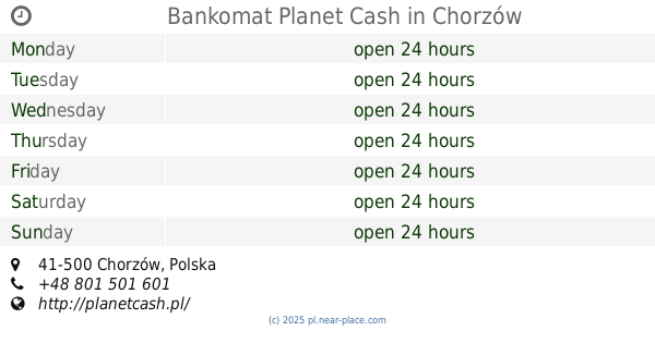
Atm nearby Planet Cash. Wpłatomat
Coronavirus disease (COVID-19) Situation
confirmed cases
6661991
deaths
120598
Poland
Atm nearby Planet Cash. Wpłatomat
Planet Cash. Wpłatomat
36, Gałeczki, 41-500, Chorzów, Chorzów, PL Polska
contacts phone
:
+48
Latitude:
50.2856804
, Longitude:
18.9580895
larger map & directions
read more
nearest Atm
153 m
Euronet Polska Sp z o. o.
Gałeczki 30, Chorzów
Atm
read more
375 m
Planet Cash. Bankomat
Ryszki 57, Chorzów
Atm
read more
375 m
Planet Cash. ATM
Ryszki 57, Chorzów
Atm
read more
425 m
PKO Bank Polski S.A.
Ryszki 59, Chorzów
Atm
read more
597 m
Euronet
Hajducka 57, Chorzów
Atm
read more
735 m
Euronet
Ułańska 10, Katowice
Atm
read more
743 m
Euronet
BP, Drogowa Trasa Średnicowa 48, Chorzów
Atm
read more
757 m
Wpłatomat mBank
Centrum, 41-500
Atm
read more
762 m
Bankomat Planet Cash
Chorzów
Atm
read more
766 m
Planet Cash
Parkowa 20, Chorzów
Atm
read more
818 m
Cash
Parkowa 20, Chorzów
Atm
read more
818 m
Cash4You. Bankomat
Parkowa 20, Chorzów
Atm
read more
818 m
Bank Zachodni WBK
Parkowa 20, Chorzów
Atm
read more
836 m
Euronet
Sportowa 31, Chorzów
Atm
read more
974 m
PKO BP I Oddział
Fryderyka Chopina 10, Chorzów
Atm
read more
985 m
Planet Cash. ATM
Długa 67, Chorzów
Atm
read more
985 m
Planet Cash. Bankomat
Długa 67, Chorzów
Atm
read more
1.05 km
Górnośląski Bank Gospodarczy SA
Powstańców 26, Chorzów
Atm
read more
1.06 km
Euronet Polska Sp z o. o.
ul. Powstańców 26, Getin Bank - Oddział, Chorzów
Atm
read more
1.118 km
Raiffeisen Bank Polska S.A.
Wolności 45, Chorzów
Atm
read more
1.118 km
Euronet
Wolności 45, Chorzów
Atm
read more
1.118 km
Raiffeisen Polbank
Wolności 45, Chorzów
Atm
read more
1.14 km
Euronet Polska Sp z o. o.
ul. Bolesława Chrobrego 13, BGC, Chorzów
Atm
read more
1.154 km
Planet Cash. Bankomat
Ludwika Zamenhofa 2, Chorzów
Atm
read more
1.251 km
Planet Cash. Bankomat
Strzelców Bytomskich 16, Chorzów
Atm
read more
📑
all categories
Accounting
Administrative area level 1
Administrative area level 2
Airport
Amusement park
Aquarium
Art gallery
Atm
Bakery
Bank
Bar
Beauty salon
Bicycle store
Book store
Bowling alley
Bus station
Cafe
Campground
Car dealer
Car rental
Car repair
Car wash
Casino
Cemetery
Church
City hall
Clothing store
Colloquial area
Convenience store
Courthouse
Dentist
Department store
Doctor
Electrician
Electronics store
Embassy
Finance
Fire station
Florist
Food
Funeral home
Furniture store
Gas station
General contractor
Grocery or supermarket
Gym
Hair care
Hardware store
Health
Hindu Temple
Home goods store
Hospital
Insurance agency
Intersection
Jewelry store
Laundry
Lawyer
Library
Light rail station
Liquor store
Local government office
Locality
Locksmith
Lodging
Meal delivery
Meal takeaway
Mosque
Movie rental
Movie theater
Moving company
Museum
Natural feature
Neighborhood
Night club
Painter
Park
Parking
Pet store
Pharmacy
Physiotherapist
Place of worship
Plumber
Point of interest
Police
Political
Post office
Premise
Real estate agency
Restaurant
Roofing contractor
Route
Rv park, camping
School
Shoe store
Shopping mall
Spa
Stadium
Storage
Store
Subpremise
Subway station
Supermarket
Synagogue
Taxi stand
Train station
Transit station
Travel agency
University
Veterinary care
Zoo
administrative area level 3
sublocality level 1
↑