Atm nearby Euronet
Poland
Atm nearby Euronet
Euronet
13, Długa, 61-845, Poznań, Poznań, PL Polska
contacts phone
:
+48 22 519 77 71
website:
www.euronetpolska.pl
Latitude:
52.403843
, Longitude:
16.9304861
larger map & directions
read more
nearest Atm
14 m
Alior Bank
Półwiejska 13, Poznań
Atm
read more
24 m
Euronet
Półwiejska 13, Poznań
Atm
read more
148 m
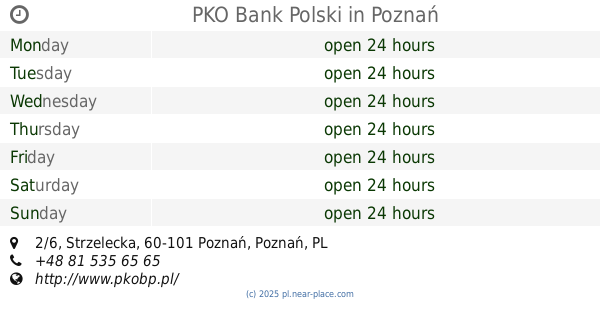
PKO Bank Polski
Strzelecka 2/6, Poznań
Atm
read more
230 m
Bank Pekao
ul. Półwiejska 32, Centrum handlowe STARY BROWAR, Poznań
Atm
read more
232 m
DB
Święty Marcin 2, Poznań
Atm
read more
300 m
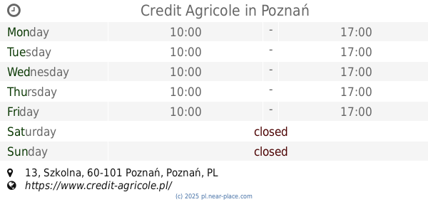
Credit Agricole
Szkolna 13, Poznań
Atm
read more
316 m
ATM - Euronet
Święty Marcin 24, Poznań
Atm
read more
390 m
DB
Półwiejska 42, Poznań
Atm
read more
435 m
Euronet
ul. Półwiejska 47, Biurowiec, Poznań
Atm
read more
446 m
bankomat euronet
Szkolna 1, Poznań
Atm
read more
499 m
Bank BPH - Bankomat partnerski
Ratajczaka 31, Poznań
Atm
read more
544 m
bankomat
Święty Marcin 43, Poznań
Atm
read more
613 m
Bankomat Banku Pekao S.A.
ul. Święty Marcin 52/56, siedziba Oddziału, Poznań
Atm
read more
619 m
ATM of Bank Pekao SA
Stary Rynek 97/98, Oddział w Poznaniu Stary Rynek 97/98, Poznań
Atm
read more
619 m
Bankomat Banku Pekao S.A.
Stary Rynek 97/98, Oddział w Poznaniu Stary Rynek 97/98, Poznań
Atm
read more
678 m
Bank Zachodni WBK
Święty Marcin 66/72, Poznań
Atm
read more
687 m
Planet Cash. Wpłatomat
27 Grudnia 13, Poznań
Atm
read more
688 m
Bank Pekao
ul. Masztalarska 8 A, siedziba Oddziału, Poznań
Atm
read more
827 m
PKO BP
Święty Marcin 78, Poznań
Atm
read more
872 m
Bank Gospodarki Żywnościowej SA
Libelta 6, Poznań
Atm
read more
892 m
Euronet
Młyńska 14, Poznań
Atm
read more
967 m
Euronet
Małe Garbary 9, Poznań
Atm
read more
1.048 km
Euronet
Szyperska 14, Poznań
Atm
read more
1.069 km
Euronet
Garbary 95, Poznań
Atm
read more
1.274 km
Planet Cash
Osiedle Piastowskie 17, Poznań
Atm
read more
📑
all categories
Accounting
Administrative area level 1
Administrative area level 2
Airport
Amusement park
Aquarium
Art gallery
Atm
Bakery
Bank
Bar
Beauty salon
Bicycle store
Book store
Bowling alley
Bus station
Cafe
Campground
Car dealer
Car rental
Car repair
Car wash
Casino
Cemetery
Church
City hall
Clothing store
Colloquial area
Convenience store
Courthouse
Dentist
Department store
Doctor
Electrician
Electronics store
Embassy
Finance
Fire station
Florist
Food
Funeral home
Furniture store
Gas station
General contractor
Grocery or supermarket
Gym
Hair care
Hardware store
Health
Hindu Temple
Home goods store
Hospital
Insurance agency
Intersection
Jewelry store
Laundry
Lawyer
Library
Light rail station
Liquor store
Local government office
Locality
Locksmith
Lodging
Meal delivery
Meal takeaway
Mosque
Movie rental
Movie theater
Moving company
Museum
Natural feature
Neighborhood
Night club
Painter
Park
Parking
Pet store
Pharmacy
Physiotherapist
Place of worship
Plumber
Point of interest
Police
Political
Post office
Premise
Real estate agency
Restaurant
Roofing contractor
Route
Rv park, camping
School
Shoe store
Shopping mall
Spa
Stadium
Storage
Store
Subpremise
Subway station
Supermarket
Synagogue
Taxi stand
Train station
Transit station
Travel agency
University
Veterinary care
Zoo
administrative area level 3
sublocality level 1
↑